Intra-Caldera Lavas and Resurgent Domes. After eruption of the Lava Creek
tuff, lava erupted inside the caldera
(intra-caldera lavas) as thick flows and
domes of obsidian or rhyolite.
Most of the early flows have been covered by younger rocks — the oldest ones are exposed
near the Grand Canyon of the Yellowstone (yellow and orange overlay to northeast), and on the
Mallard Lake dome (same colors to southwest).
The Mallard Lake and Sour Creek (greens overlay, to northeast) structures are
resurgent domes that formed as magma forced its way
toward the surface. Both domes are scarred by faults (black lines) where the rock broke as the
domes were pushed up. The Sour Creek dome exposes Lava
Creek Tuff. The Mallard Lake dome may still be growing today!
From Plate 1 of Christiansen (2001).
|
|
Post-Dome Lava Flows. Flows of obsidian and rhyolite lava continued to
leak out of the magma chamber. Most of the flows are in the caldera (and overflow its
southwest rim). A few flows, including Obsidian Cliff, erupted along a buried fault
that trends north-south from Mammoth Hot Springs through Norris Geyser Basin, and beyond the
Yellowstone caldera to the south. The eruptions seem to have come in waves, with groups of flows
forming at ~480,000 years ago, ~200,000 years ago, ~160,000 years ago, ~110,000 years ago,
and ~70,000 years ago.
From Table 2 and Plate 1 of
Christiansen (2001).
|
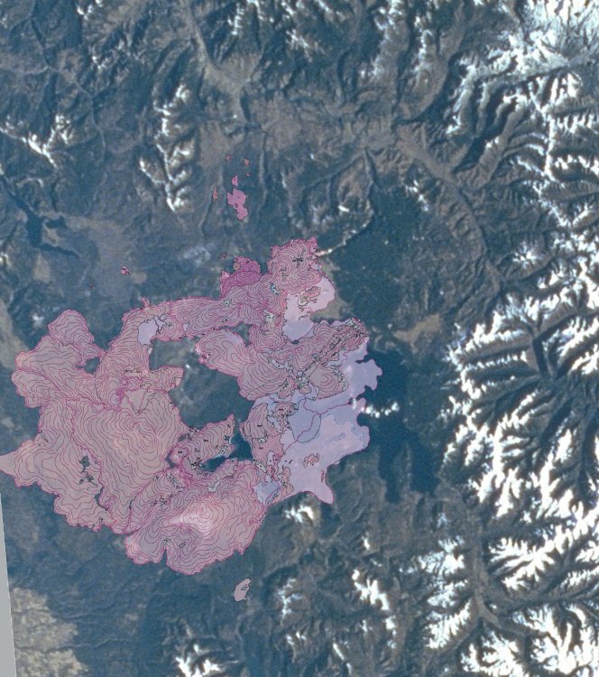
Glaciers After the most recent eruptions at 70,000 years ago, Yellowstone was
completely buried in ice. During the last ice age, ~ 50,000 to ~ 10,000 years ago, glaciers grew
on the tall mountains and plateaus of the Yellowstone region, forming the "Yellowstone ice cap." Its
maximum extent is shown by the pale white overlay on this space shuttle image, and the deepest ice
(estimated at nearly a kilometer) is in the brighter white overlays. High spots were worn down, and
low spots were filled with glacial sediments. New low spots, like the main part of Yellowstone lake,
were carved by these glaciers.
|
|
Hot Waters Yellowstone's hot springs and hydrothermal features (red)
extend far beyond the famous areas
accessible from the higways. Most of the hot spring areas and geyser basins are inside
the ring fracture of the calderas (dashed black line). A second group are along a buried fault
that extends from Mammoth Hot Springs south through Roaring Mountain and Norris Geyser basin, and
through the caldera to the south. Inside the caldera, hot spring and geyser areas are concentrated
where the late obsidian flows are not — the heat and hot water are presumably still
there, but the obsidian seals them in. Includes both active and extinct hydrothermal systems;
from Figure 29 of Christiansen (2001).
|