

Mapping Channels and Craters on Mars
Background
Scientists use maps to illustrate the geologic history of a planet or moon. Geologic maps show present day features and evidence of past events. The maps show features that were formed earlier or later than others, giving scientists a relative time sequence of events (not precise dates). On Earth these maps are made using photographs taken from airplanes and spacecraft, and from research on the Earth’s surface. To make maps of other planets we must use photographs taken by spacecraft and use lander information from the planet’s surface.Objective
Students will make a simple features map and interpret the geologic history of a part of Mars surface.
 |
 |
Materials
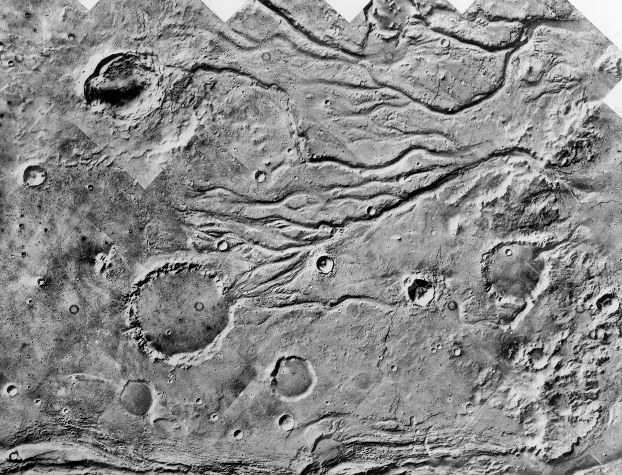
- Photo of Mars’ surface showing outflow channels emptying into northern plains of Chryse Planitia (you can download one of the images shown above).
- Tracing paper or transparencies, one per paper photo.
- Tape or paper clips.
- Colored markers (three colors--red, green, and blue—are used in the discussion below)
The following materials are needed if this activity is completed as a group procedure:
- Slide projector or viewgraph projector.
- Large sheet of paper (not shiny) or a nonshiny erasable white board may be used--test first.
- Masking tape.
- Make a viewgraph transparency of one of the channel images shown above.
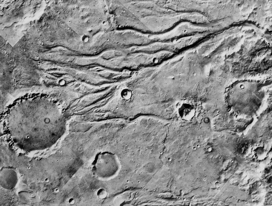
- Alternatively, you can use this image showing a slightly larger version of the region mapped in this activity.
Advance Preparation
- Gather materials.
- Become familiar with the important features in the Mars photo.
- Practice determining the up and down slopes of the features by paying attention to the Sun illumination angle and the shadows on the features.
Procedure for Individuals (the steps below are for individuals or pairs using a paper copy of the Mars image).
- Secure a transparency or sheet of tracing paper to the top of the Mars photo.
- Distribute materials.
- Tell students that this is a spacecraft photograph of an area on Mars around 20°N latitude and ~55°W longitude, at the northern edge of Chryse Planitia. The image shows impact craters and river channels. The area is about 200 kilometers across. No one has ever been here, but we can figure out things about this part of Mars by mapping and thinking.
- Show students an example of a crater with a continuous, sharp-edged, unbroken rim.
- Note that they should draw the rim and not the fairly flat interior (see drawing on student sheet). If time and skill allow, students may also note and draw the ejecta for the fresh, sharp-rimmed craters. The ejecta is the material that is blasted out of the crater and falls outside the rim of the crater. The ejecta is usually more irregular than most of the craters. Review with students how to tell what is a depression and what is a hill slope by knowing the direction of illumination from the Sun.
- Have students color all sharp-edged craters red.
- Show students an example of a crater with an uneven, eroded, broken rim (see student sheet).
- Have students color all eroded craters green.
- Show students an example of a river channel.
- Have students color all channels blue. They may try to show both sides of the channel, but a single line in the middle of the channel is adequate.
- Have students lift the transparencies and look at it. Ask the students what they have made. (They have made a simple feature map.)
- Proceed to the Questions and Discussion.
Group Procedure (the steps below are for a large group activity using a slide).
- Tape a large sheet of paper to the wall.
- Project the image on the paper, so it is as large as possible. Be aware that it will be easier to clearly distinguish details on the image from several feet away. When students draw on the paper they will either need to ask for some help from classmates or step back frequently. This leads to a good cooperative activity.
- Tell students that this is a spacecraft photograph of an area on Mars around 20°N latitude and ~55°W longitude, at the northern edge of Chryse Planitia. The image shows impact craters and river channels. The area is about 200 kilometers across. No one has ever been here, but we can figure out things about this part of Mars by mapping and thinking.
- Show students an example of a crater with a continuous, sharp-edged, unbroken rim.
- Note that they should draw the rim and not the fairly flat interior (see drawing on student sheet). If time and skill allow, students may also note and draw the ejecta for the fresh, sharp-rimmed craters. The ejecta is the material that is blasted out of the crater and falls outside the rim of the crater. The ejecta is usually more irregular than most of the craters.
- Have a student or group of students color all sharp-edged craters red.
- Show students an example of a crater with an uneven, eroded, broken rim (see student sheet).
- Have students color all eroded craters green.
- Show students an example of a river channel.
- Have students color all channels blue. They may try to show both sides of the channel but a single line is adequate.
- Turn off the overhead projector and ask the students what they have made. (They have made a simple feature map.)
- Proceed to the Questions and Discussion.
QUESTIONS AND KEY
- Q. Which are older, river channels or green craters? How do you know?
A. Green craters are older. When a river channel met a green crater the water broke through the rim, entered the crater, broke out somewhere else, and kept going. - Q. Which are older - river channels or red craters? How do you know?
A. River channels are older. When an impact formed a red crater on top of a river channel the crater covered the channel, but the crater was not eroded. The river had stopped flowing. - Q. Which features are oldest, youngest, and of medium age?
A. Green craters are oldest, red craters are youngest, river channels are of medium age. Using the data from questions 1 and 2, the green craters were there before the channels, and the channels were there before the red craters. - Q. Are big craters older or younger than small craters? A. Big (green) craters are older than small (red) craters. The green craters tend to be larger while the red ones are generally smaller. The same observation that the green craters were there before the channels and the red craters were formed after the channels sets the larger green craters as being older.
- Q. Write a simple geologic history of this part of Mars.
A. First large meteorites hit the surface and made big craters. Later flowing water formed river channels which cut through some of the old craters. After a while the rivers stopped flowing. Even later smaller meteorites hit the surface. Some of these formed craters on top of the dry channels.
Extra credit
- Q. Why are the old craters larger than the young craters?
A. Most of the big meteorites hit a long time ago. Later only smaller meteorites were left. The earlier meteorites were very large pieces of planetary material that were still being pulled together through the process of solar system accretion. As time passed, the impacts were caused by the smaller pieces of material left-over from the accretion process. - Q. Which way does the land slope?
A. The land slopes downwards from the west to the east. River channels combine as you go downhill. A map of the Mississippi River or some other terrestrial river basin may be used as a comparison.
Credit: This activity was developed at the Johnson Space Center as part of the Destination Mars curriculum.
