The Lunar Orbiter Program
The Lunar Orbiter program, initiated in early 1964, consisted of the investigation of the Moon by five identical unmanned spacecraft. The spacecraft weighed approximately 390 kilograms at launch, were 1.5 meters in diameter, and were 2 meters in length. Solar panels supplied the required power. The main purpose of the program was to locate smooth, level areas on the Moon’s nearside to confirm the areas as suitable for manned landing sites for the Apollo program. The specific objectives of the Lunar Orbiters were as follows:
- Photography. To obtain detailed lunar topographic and geologic information of various lunar-terrain types to assess their suitability for use as landing sites by Apollo and Surveyor spacecraft and to increase man’s scientific understanding of the Moon.
- Selenodesy. To provide precision trajectory information that would improve the definition of the lunar gravitational field.
- Analysis of the Moon’s environment. To provide measurements of the micrometeoroid and radiation flux in the lunar environment for spacecraft performance analysis.
During the first three missions, 20 potential lunar landing sites were photographed from low-inclination and comparatively low-altitude orbits. Analysis of the photography indicated that nearly all Lunar Orbiter program objectives had been met. Eight promising sites were selected for manned landings with additional photography required for confirmation of five of these sites.
The fourth and fifth missions were devoted to broader scientific objectives. The entire nearside of the Moon, and 95% of the farside, was photographed from high-altitude orbit. In addition, medium- and high-resolution photography of 36 preselected areas containing features of interest were acquired along with the additional photography required for confirmation of the Apollo landing sites.
With the completion of the five Lunar Orbiter missions, 99% of the Moon was photographed with resolution of 60 meters or better. This was 10 times better resolution than the best observations from Earth.
The Lunar Orbiter 1 Mission
Mission Description
Launch: 10 August 1966
Imaged Moon: 18–29 August 1966
Apollo landing site survey mission
During its 35-day mission, Lunar Orbiter 1 collected an enormous quantity of data on the topography of the lunar surface. A total of 413 high- and moderate-resolution photographs were taken. This included 262,000 square kilometers of the nearside of the Moon and over 3,000,000 square kilometers of the farside. All the primary photo sites were photographed as planned, except for sites I–4, I–6, and I–8.1. The orbiter also obtained environmental data during all periods of visibility and from the cumulative effect of periods of occultation. In addition, over 1000 station hours of tracking data were obtained. These were used to further define the lunar gravitational field.Selection of the Target SitesA set of ground rules was established to guide and direct selection of appropriate targets sites. Among the objectives were (1) to obtain samples of significant terrain types, (2) to concentrate on the most promising areas within the Apollo zone, and (3) to examine promising Surveyor sites. The results of the Ranger 7,8, and 9 missions contributed a great deal of supporting data. Surface roughness was of primary concern from the standpoint of landing requirements for the Apollo missions. Possible information of scientific value, as well as of direct value to the Apollo mission, was also considered in the selection of target sites. A total of 10 sites were chosen for this mission.
The Lunar Orbiter 2 Mission
Mission Description
Launch: 6 November 1966
Imaged Moon: 18-25 November 1966
Apollo landing site survey mission
The primary objectives for this mission were to obtain detailed photographic information of various lunar areas, to assess their suitability as landing sites for Apollo and Surveyor spacecraft, and to improve our knowledge of the Moon. Secondary objectives were to provide precision trajectory information for use in improving the definition of the lunar gravitational field and to provide measurements of micrometeorite flux and radiation dose in the lunar environment. All mission objectives were met on this mission with a total of 211 photographs taken in 40 orbits of the Moon. Some photographs were not transmitted, however, when the transmitting equipment failed during the readout operation. Only a small number of pictures were lost and other data collection was not affected. Lunar Orbiter 2 made significant additions to the techniques and data required to land on the Moon and return safely.
Selection of the Target Sites
The objectives and ground rules for this mission stipulated that the primary sites to be photographed have the potential of being acceptable Apollo landing sites according to location, topography, and soil mechanics. Lunar Orbiter 2 sites were located along a northern latitude band within the Apollo zone. The final site selection included 13 primary sites and 17 secondary sites, with some of the latter on the lunar farside.
The Lunar Orbiter 3 Mission
Mission Description
Launch: 5 February 1967
Imaged Moon: 15-23 February 1967
Apollo landing site survey mission
The primary objective of Lunar Orbiter 3 was to continue the Orbiter 1 and Orbiter 2 task of photographing promising areas of the lunar surface to determine their adequacy as Apollo and/or Surveyor landing sites. Mission 3 differed from the previous two missions in that it was a site confirmation mission rather than a site selection mission. To provide access to both mission 1 and 2 primary sites with acceptable lighting conditions, the orbit inclination of this mission was increased to 21°. Mission photography was conducted as planned except for minor shifts in some photo site locations, the addition of a fourth pass over the Surveyor 1 landing site, and the cancellation of the last secondary site. During 54 successive orbits, a total of 211 exposures were taken. Unfortunately, only about 75% of these were transmitted before a failure in the film-advance motor terminated the readout operation.
Selection of the Target Sites
Primary photo site selection was based on screening of the Lunar Orbiter 1 and 2 photographs. Twelve primary sites (including the landing area of Surveyor 1) and 32 secondary sites were selected. The secondary sites included different terrain types from Apollo support sites, which were all maria. They provided information of value in selection of nonmare Surveyor landing sites.
The Lunar Orbiter 4 Mission
Mission Description
Launch: 4 May 1967
Imaged Moon: 11-26 May 1967
Lunar mapping mission
Mission 4 differed greatly from the previous missions in both concept and conduct. Because the Lunar Orbiter program tasks had been completed during the first three missions, project objectives were extended to increasing the understanding of the Moon as a whole. Surveying the entire lunar surface and examining in detail various surface geological processes became the new objectives. The secondary objectives of obtaining gravitational field and environmental information remained the same. Active photography was initiated on May 11, 1967. During 30 successive orbits over 15 days, 199 dual-frame exposures were taken. Despite some operational problems during the mission, Orbiter 4 was highly successful in fulfilling its purpose. The photographs obtained provided information and detail at least 10 times better than Earth-based observations.
Selection of the Target Sites
This mission did not involve photography of particular sites in the sense of the preceding missions. Except for the first orbit, photographs were taken as individual, single-frame exposures. For this reason, each frame was considered as a site. For operational purposes, nine photographic zones were designated. However, by the end of the mission, nearly the entire nearside surface and an appreciable amount of the farside had been photographed.
The Lunar Orbiter 5 Mission
Mission Description
Launch: 1 August 1967
Imaged Moon: 6-18 August 1967
Lunar mapping and high-resolution survey mission
Mission 5, the last of the Lunar Orbiter missions, was basically similar to the first three missions but with two important differences. These were a highly inclined (85°) orbit (as was used for mission 4) and an increase in the number of individual photographic sites. The number of frames used for farside photography was also increased. A total of 174 exposures were taken in 50 sequences during 69 orbits. With the exception of the addition of the Earth photo site and some relocations of photo sites during the mission, the photo mission was accomplished according to premission plans. Lunar Orbiter 5 significantly increased the photographic data available on the lunar surface. Photography at least an order of magnitude improvement in resolution over mission 4 was obtained for numerous areas of particular interest on the nearside, and farside photography provided coverage of essentially all areas not covered during the preceding four missions.
Selection of the Target Sites
To expedite planning, initial selection of mission 5 sites was made prior to the availability of mission 4 photographic data. When this data became available for additional evaluation of the initial site selections, a few sites were deleted and the location of others were modified to obtain more significant data. Photo sites included candidate Apollo landing sites, Apollo applications program sites, Surveyor landing sites, and scientifically interesting sites. In all, 69 photo sites were selected, 45 on the nearside, and 24 on the farside.
The Lunar Orbiter Photographs
The five Lunar Orbiter spacecraft returned over 1654 high-quality photographs taken from lunar orbit. Each spacecraft was similarly equipped with two cameras that operated simultaneously and had the same line of sight but different fields of view and resolutions. The cameras utilized a common supply of 70-millimeter film, and the dual images they recorded are referred to as medium-resolution frames and high-resolution frames.
Of the 1654 Lunar Orbiter photographs, 840 depict areas photographed on the basis of Apollo program requirements and were obtained primarily during missions 1, 2, and 3. They were taken from low flight altitudes and provided detailed coverage of 22 areas along the equatorial region of the nearside of the Moon. The remaining 814 photographs were taken primarily during missions 4 and 5 and included 703 of the lunar nearside, 105 of the lunar farside, and 6 of Earth. These photographs were taken from flight altitudes ranging from approximately 44 kilometers over the nearside to approximately 6000 kilometers over the farside. They provide broad coverage of essentially the entire Moon and detailed coverage of 88 areas on the nearside.
The photographic system was housed in a pressurized, thermally controlled container, and included the cameras, film and film handling, film processor, and a readout device for transmission to Earth by the communications system. The two cameras simultaneously placed two discrete frame exposures on a common supply of 70-millimeter aerial film. Each camera operated at a fixed aperture of f/5.6 with controllable shutter speeds of 0.001, 0.02, or 0.04 seconds. One of the lenses had a 610-millimeter focal length, the other an 80-millimeter focal length. The film was developed onboard by passing the film into contact with a web that contained a single-solution processing chemical. After the film was dried, it was stored to be read out and transmitted to Earth.
Lunar Orbiters 1, 2, and 3 were primarily dedicated to imaging prospective Apollo landing sites in the equatorial region of the lunar nearside. Lunar Orbiter 4 was dedicated to providing complete imaging coverage of the lunar nearside, and Lunar Orbiter 5 provided high-resolution imaging of selected sites of high scientific interest. Nearly complete coverage of the lunar farside was also obtained over the course of the five missions.

Lunar Nearside Locator Map
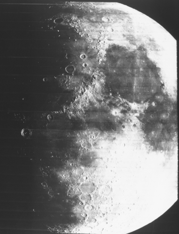
Features visible in this image of the eastern part of the lunar nearside include Mare Serenitatis and Mare Tranquillitatis, as well as the eastern portion of Mare Imbrium. (Lunar Orbiter image IV-109M.)
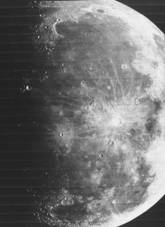
Features visible in this image of the western part of the lunar nearside include Mare Imbrium, Mare Humorum, Mare Nubium, and the craters Copernicus and Kepler. (Lunar Orbiter image IV-138M.)
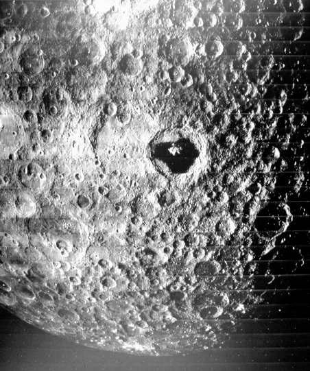
This image shows a portion of the Moon’s farside, which is heavily cratered. Smooth mare regions are rare on the lunar farside. The floor of the crater Tsiolkovsky near the center of the image is an example of a large, smooth region on the farside. Tsiolkovsky is 180 kilometers across. (Lunar Orbiter image III-121M.) Apollo 15 photographs of Tsiolkovsky.
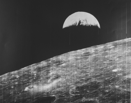
This image, obtained on August 23, 1966, provided our first look at Earth from the vicinity of the Moon, at a distance of 380,000 kilometers. Parts of Europe and Africa are visible on Earth. Because the Sun is nearly overhead in this image, there are few shadows visible on the Moon. Nevertheless, the rugged nature of the Moon’s farside is apparent in this image. (Lunar Orbiter image I-102H2.)
