
From Ranger VIII to Apollo 11:
Pioneering an Integrated Robotic and Human Exploration Program
By David A. Kring
(Supplementing an article in Eos, v. 96, doi:10.1029/2015EO024575, 19 February 2015)
The robotic Ranger VIII spacecraft was launched towards the Moon February 17, 1965. Three days later the vehicle flew towards the lunar surface, providing our first glimpse of what would become Tranquility Base when humans stepped on another planetary surface for the first time. Together, the robotic Ranger VIII mission and the subsequent Apollo 11 mission illustrated the tremendous value of an integrated robotic and human space exploration program.
Robotic Precursors
The Ranger program was initiated in 1959 to conduct lunar science and compete with the Soviet Union’s Luna Program, which had already that year flown past the Moon (Luna 1, January), hit the Moon (Luna 2, September), and orbited and photographed the lunar farside (Luna 3, October).

A complete list of lunar-related missions is available in LPI’s Lunar Exploration Timeline.
The Ranger program was redirected to support the Apollo program when, in 1962, President Kennedy announced plans to safely land astronauts on the Moon and return them to Earth. The Ranger missions’ primary objective was to determine the “fine-scale” structure of the lunar surface and, thus, determine if it was safe for robotic and human landings [Shoemaker, 1966; Trask, 1970]. They did so by flying towards the Moon, taking photographs at increasingly lower altitudes until they hit the lunar surface.
 Ranger VII was the first successful mission in this series, producing a string of images before hitting the surface of Mare Cognitum, south of the equator on the western portion of the lunar nearside. Surveyor III and Apollo 12 would return that region in the future.
Ranger VIII, however, provided the initial data for what would become Tranquility Base. Ranger VIII targeted Mare Tranquillitatis, in part because it was a relatively flat terrain close to the equator and, thus, where astronauts could land. Ranger VIII reached the Moon three days after launch and targeted the southwestern portion of Mare Tranquillitatis, which was interpreted by geologists as a flood basalt province. The spacecraft carried six television cameras with different exposure times, fields of view, lenses, and scan rates. Before impacting the lunar surface at a velocity of ~2.68 km/s (~9650 km/hr), full scans from cameras A (a wide-angle 25º field of view) and B (a narrow angle 8.4º field of view) were transmitted back to Earth, providing 60 and 90 frames, respectively, with about five seconds between frames on each camera. Camera B was aimed farther south than Camera A and captured the terrain along a path that passed only 27 km north of what would become Tranquility Base. Several pictures in that sequence captured what would become Tranquility Base from an altitude as low as 229 km. The vehicle hit the lunar surface 68 km NNE of Tranquility Base.
The images from Ranger VIII and other Ranger spacecraft are available in an atlas of Ranger Photographs of the Moon. In addition, image loops produced from cameras A and B can be seen that show the vehicle approaching the lunar surface.
The images were used to generate Ranger Lunar Charts (RLCs) that were shaded relief maps with the topography of the lunar surface, including the depths of impact craters based on measured shadow lengths. (To see how the method works, students may want to try a laboratory exercise using shadow lengths in a picture that astronauts took of Meteor Crater on Earth.) RLC 6 and RLC 7 capture the future site of Tranquility Base [Ranger VIII Lunar Charts, 1966]. In parallel, a series of geologic maps were being generated by the USGS. Using Ranger VIII images, Wilshire [1967] completed a preliminary map of the Sabine Region, including the area where Apollo 11 would land, at the 1:250,000 scale. However, work on the on Ranger-based maps slowed as personnel began working with Lunar Orbiter images.
The Lunar Orbiter (LO) program began in 1964 and generated five spacecraft that were specifically designed to photograph potential landing sites for Apollo. Based on those results, eight sites were selected for additional study. Grolier was assigned the geology of Apollo Landing Site 2. He based his map principally on 7 high-resolution images from Lunar Orbiter II, which flew in November 1966, and generated 211 pictures with spatial resolutions as small as 1 meter. He generated two maps that were available to mission planners, but not published until after Apollo 11 [Grolier, 1970a,b]. The first geology map is at a scale of 1:100,000 and the second geology map is at 1:25,000, the latter of which was the scale essential to selecting the landing site. (As described below, the Apollo 11 astronauts landed long of their intended site, so a strip of newly mapped geology is evident in the 1970 version of the 1:25,000 scale map.)
Images produced by the Lunar Orbiter program are available in The Lunar Orbiter Photo Gallery and the Digital Lunar Orbiter Photographic Atlas of the Moon.
To test surface conditions and demonstrate soft landing capabilities, the Surveyor program was initiated while those photogeologic studies were underway. Within a year of the Lunar Orbiter II flight, Surveyor V landed in a small 9 × 12 meter crater 25 km NW of Tranquility Base. The vehicle survived three lunar nights (lengthy 14-day-long periods without sunlight), finally succumbing ~107 days after landing and after transmitting 19,118 pictures. This was the first Surveyor to carry an alpha-particle backscattering instrument and, thus, produced the first chemical analysis of the lunar surface. Geologists were excited to confirm that the maria were composed of basalt [Turkovich et al., 1968], which also confirmed the Moon was a differentiated planetary body [Gault et al., 1968]. A magnet on the spacecraft attracted material and, from that observation, it was concluded (incorrectly) that the soil contained pulverized basalt with 10 to 12% magnetite and <1% metallic iron. As we now know, lunar lithologies were produced under far lower oxygen fugacities than terrestrial basalts. There is very little magnetite on the Moon.
As robotic data were acquired, they were presented to the Apollo Site Selection Board, which was trying to refine the best sites for future missions, including the critical first landing. To illustrate the types of issues being examined, we highlight here the Apollo Site Selection Board Briefing of December 15, 1967. Apollo Landing Site 2 was, at that time, called Site II P-6. In the briefing book, one can find an image of the lunar surface during a LM’s approach to the candidate landing site along with a map of topographic microfeatures: ejecta and rock fields; domes and ridges; rilles; scarps; other lineations; conical craters; crater chains; and other depressions in the vicinity of an estimated landing ellipse. The 1967 briefing book shows that Site II P-6 met most of the operational criteria: Service Propulsion System propellant limits; daylight launch; LM approach limits; no Earth shadow problem; acceptable LM yaw during descent; Manned Space Flight Network tracking time prior to descent; Sun elevation; free return inclination; and free return landing point. Site II P-6 was, from an operational standpoint, the most desirable landing site and accessible all year long, whereas sites on the western half of the nearside were accessible during only specific times of the year. Another Mare Tranquillitatis landing site, II P-2, remained attractive based on operational criteria.
To assist lunar science investigators, engineers, astronauts, and others with the development of Apollo surface operations, the precursor data were organized into a series of lunar surface data books. Each book covered an area eight degrees in latitude (N-S) and five degrees in longitude (E-W). Lunar Surface Data Book 5 (00-08N/20-25E) covered the region photographed by Ranger VIII and where Apollo 11 would eventually land. These data books were prepared for the Mapping Sciences Laboratory at the Manned Spacecraft Center in Houston and delivered in January 1969. In a very succinct fashion, book number 5 presented the photography, topography, geology, and engineering properties of the region around Apollo Landing Site 2. Other data books in the series presented the same types of information for other candidate landing sites.
Human Exploration
The site for the first human landing was still undecided, even though many of the Apollo systems had been developed and tested in a series of missions that had already carried astronauts around the Moon. There were several candidate landing sites for Apollo 11, including what had become known as Apollo Landing Site 2 in southwestern Mare Tranquillitatis. The Ranger VIII, Lunar Orbiter II, and Surveyor V spacecraft had provided important precursor data for that area. The next step was the Apollo 10 mission, which was supposed to be a dry run for Apollo 11, in which crew would descend in a Lunar Module (LM), but not land, and then re-ascend for rendezvous with the Command Service Module (CSM).
 In 1966, Apollo astronaut Harrison "Jack" Schmitt (who later flew on Apollo 17) had used the last frame of Camera B on Ranger VIII to develop a hypothetical traverse for crew around a lander in Mare Tranquillitatis [Schmitt, 1966]. It provided a measure of mission reality that had been missing from the discussion and he used it to argue that Apollo 10 descend to that site. He won his argument and the launch was rescheduled for a day later so that Apollo 10 could target Apollo Landing Site 2. The LM on Apollo 10 descended from an orbit of about 100 km to an altitude of about 14.5 km and flew over Apollo Landing Site 2. These and other fascinating details of this historical sequence of events are provided by Wilhelms in his book To a Rocky Moon.
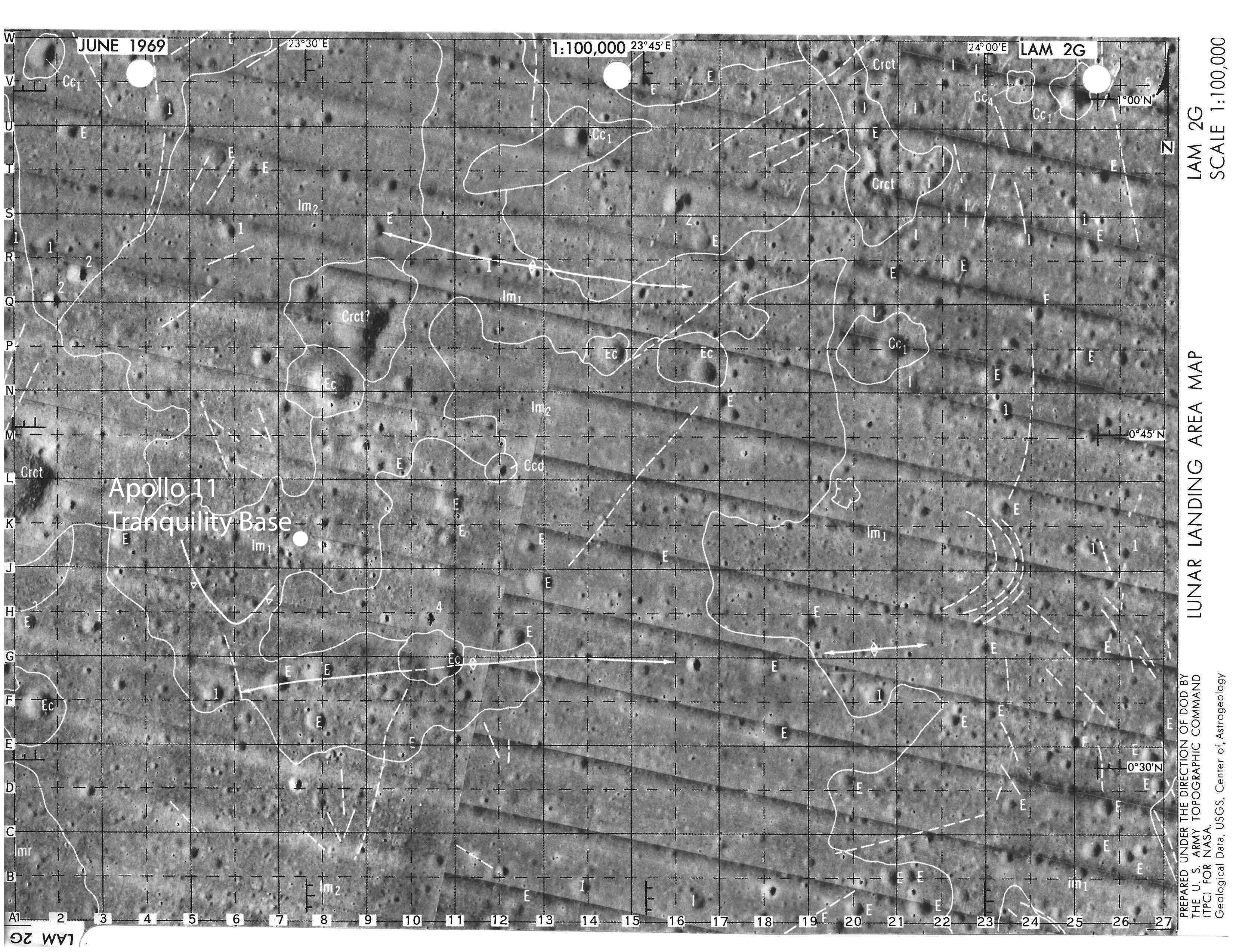
These data were used to plan the Apollo 11 mission. In particular, the images provided by the robotic spacecraft were used to generate a Lunar Surface Exploration Data Package in June 1969, which contained the 116 charts and geologic maps the Apollo 11 astronauts (Neil Armstrong, Edwin “Buzz” Aldrin, and Michael Collins) carried with them in the CSM and LM the following month. The package begins with a chart and photogeologic map of the landing area at a 1:100,000 scale. A series of 1:25,000 scale charts and photogeologic maps appear next that cover the anticipated landing ellipse. A larger series of 1:5,000 scale charts were also included, but no attempt to map geology at that scale was attempted.
On the 1:100,000 geology map, Apollo 11 landed on lm1, which is the older of two Imbrian-age mare surfaces mapped at that scale. Because of difficulties during the descent, however, Armstrong and Aldrin had flown ~7 km west of the center of the landing ellipse and ~2 km south, beyond the LO II high resolution photographic coverage that had been used to certify the site as safe [Wilhelms, 1993] and ~1.5 km beyond the geology mapped on the 1:25,000 charts.
 |
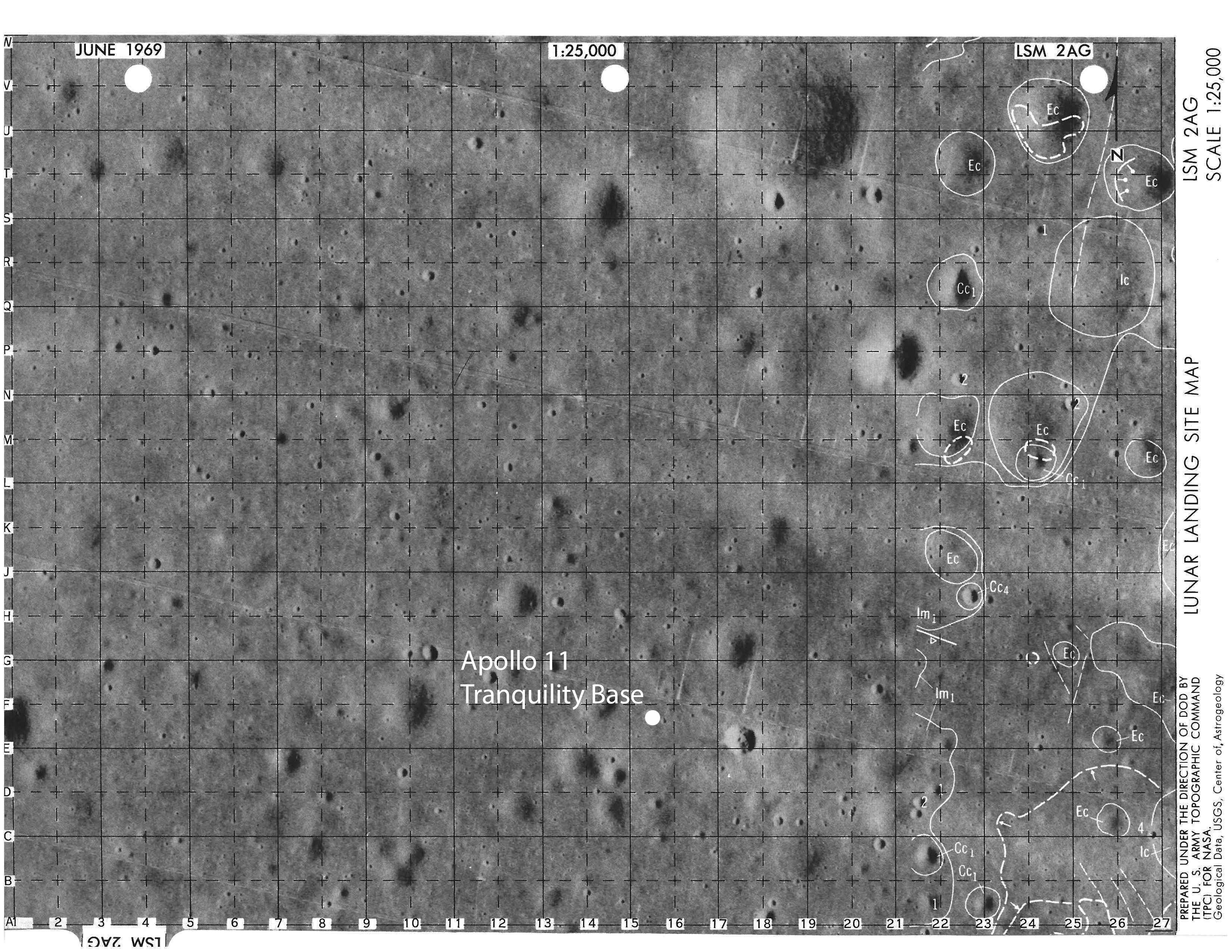 |
| Location of the Apollo 11 LM (Eagle) on chart LAM 2G, which is the 1:100,000 scale geology map. | Location of the Apollo 11 LM (Eagle) on chart LSM 2AG, which is the 1:25,000 scale geology map. The Eagle landed ~1.5 km west of the geology that had been mapped on their charts. |
| Click on the thumbnails for a larger version of the image | |
This was of little consequence, because the crew did not know where they were on those charts. Due to several problems that occurred during their descent to the lunar surface, they did not have an opportunity to monitor the landscape until they were less than 2,000 ft above the surface, at which point they did not have sufficient landmarks to locate themselves. They knew they had landed long of the center of the landing ellipse, because of spacecraft navigation errors and because Armstrong manually kept the spacecraft aloft to avoid boulders ejected from an impact crater (later identified as West Crater), but the exact position was not clear. Collins in the CSM was repeatedly tasked by Houston to locate the LM from orbit, without any luck. Just minutes before Armstrong and Aldrin launched to orbit, CapCom notified Collins of an approximately correct position as determined in Houston.
 |
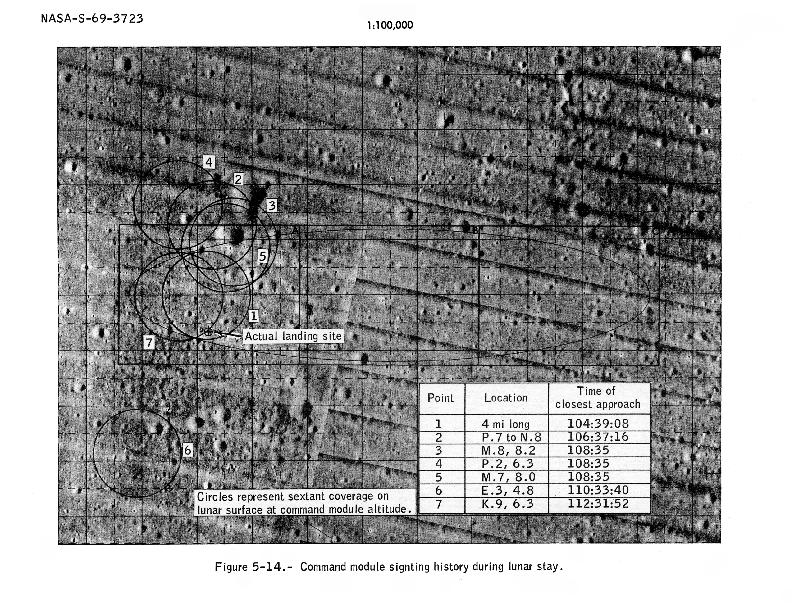 |
| Navigation errors and other issues caused the LM to overfly the center of the landing ellipse towards the boulder-strewn ejecta around a crater that we now know to be West Crater. Armstrong and Aldrin manually kept the spacecraft aloft to miss the boulders, landing slightly west of Little West Crater. | Because of problems during the descent, Armstrong and Aldrin were not sure of their location. Collins in the CSM was tasked by Houston to locate the LM. He was asked to examine several locations, shown here, as he repeatedly orbited overhead. |
| Click on the thumbnails for a larger version of the image | |
Despite the uncertain position, the value of sample return missions involving crew soon became obvious with the scientific bonanza that followed Apollo 11 and increased with each subsequent Apollo mission. The mission showed that the mare was volcanic, composed of at least two relatively Fe- and Ti-rich basalts that were very old (3.6-3.9 Ga). The regolith also contained felspathic (anorthositic) material that had been deposited by impact cratering events in the distant lunar highlands. This led to the completely novel idea that the Moon had formed as a magma ocean and that an anorthositc crust floated on that magma ocean [Wood et al., 1970a,b; Smith et al., 1970; Wood, 1970]. Finally, the mission strongly suggested that most craters on the Moon have an impact origin and are not volcanic. Those big ideas were generated from analyses of samples collected and returned to Earth after only 2.2 hours of field work that also included the deployment of a television camera, solar wind composition experiment, laser ranging retroreflector, passive seismic experiment, and lunar dust detector.

Apollo 11 astronauts collected 58 geologic samples for a total mass of 21.5 kilograms. NASA photograph AS11-40-5903.
Interestingly, on Earth the USGS created a cratered terrain with explosives to simulate an area near the center of the Apollo 11 landing ellipse, which is described in Cinder Lake Crater Fields, Arizona: Lunar Analogue Test Site to test tools, communication protocols, and other elements of lunar surface activities. Nonetheless, neither Armstrong nor Aldrin used the Mare Tranquillitatis analogue facility. They relied, instead, on the geologic principles that they were introduced to in a series of short field trips when they were initially selected to be astronauts: Meteor Crater, Sunset Crater, and the San Francisco Volcanic Field (16 January 1963); the Grand Canyon, AZ (Aldrin, Armstrong, & Collins, 5-6 March 1964), Big Bend-Marathon, TX (Aldrin & Collins, 2-3 April 1964 and Armstrong, 15-16 April 1964), Flagstaff (including a Meteor Crater flyover) & Kitt Peak, AZ (Aldrin & Collins, 30 April – 2 May 1964 & Armstrong, 20-22 May 1964), Philmont Ranch, NM (Aldrin, Armstrong, & Collins, 3-6 June 1964), Newberry Crater, OR (Aldrin, Armstrong, & Collins, 7-9 or 15-17 October 1964), Valles Caldera, NM (Aldrin, Armstrong, & Collins, 23-25 or 29-31 Oct or 13-14 Nov 1964), Hawaii (Aldrin, Armstrong, & Collins, 15-17 or 18-23 January 1965), the Nevada Test Site (Aldrin, Armstrong, & Collins, 17-18 or 24-25 Feb or 3-4 March 1965), Meteor Crater, AZ (Collins, 22-23 April 1965), and Katmai, AK (Aldrin & Collins, 28 June – 2 July 1965).
After they were selected for the Apollo 11 crew, Aldrin and Armstrong only had a single geologic tune-up, which was held at Sierra Blanca, TX (24 February 1969) – less than 5 months prior to their mission. This site was selected, in part, because it is a volcanic center with a variety of volcanic rocks. The field trip consisted of one short stop and three practice traverses.
Although the Apollo 11 crew did not have time to use the Mare Tranquillitatis analogue landing site in the Cinder Lake Crater Fields, it was used by the Apollo 12 crew when they began training for their mission. Geologic training became increasingly important with subsequent Apollo crews, particularly for astronauts on the Apollo 15, 16, and 17 missions, which helped them explore more geologically complex landing sites, travel farther distances, and collect larger numbers of samples.
References
Gault, D. E. et al. (1967), Surveyor V: Discussion of Chemical Analysis, Science, 158, 641–642.
Grolier, M. J. (1970a), Geologic Map of the Sabine D Region of the Moon, Lunar Orbiter Site II P-6, Southwestern Mare Tranquillitatis, Including Apollo Landing Site 2, 1:100,000, USGS Map I-618.
Grolier, M. J. (1970b), Geologic Map of Apollo Landing Site 2 (Apollo 11), Part of Sabine D Region, Southwestern Mare Tranquillitatis, 1:25,000, USGS Map I-619.
Lunar Surface Data Book 5 (00N/20E), Mapping Sciences Laboratory, Manned Spacecraft Center, Houston, TX, First Edition, January 1969.
Lunar Surface Exploration Map Data Package, Apollo Landing Site 2, Edition 1, June 1969.
Ranger VIII Lunar Chart Hypatia RLC 6 (1966), 1:1,000,000.
Ranger VIII Lunar Chart Sabine RLC 7 (1966), 1:250,000.
Shoemaker, E. M. et al. (1966) Progress in the analysis of the fine-structure and geology of the lunar surface from the Ranger VIII and IX photographs, in Ranger VIII and IX, Part II. Experimenters’ Analyses and Interpretations, JPL Technical Report 32–800, 249–337.
Schmitt, H. H. (1966) Utilization of high-resolution photographs in manned lunar geologic investigations, in Ranger VIII and IX, Part II. Experimenters’ Analyses and Interpretations, JPL Technical Report 32-800, 326–337.
Utilization of high-resolution photographs in manned lunar geologic investigations
Smith, J. V., A. T. Anderson, R. C. Newton, E. J. Olsen, P. J. Wyllie, A. V. Crewe, M. S. Isaacson, and D. Johnson (1970), Proc. Apollo 11 Lunar Sci. Conf., vol. 1, 897–925.
Trask, N. J. (1970), Ranger photographs of the moon, Radio Science, 5, 123–128.
Turkevich, A. L., E. J. Franzgrote, and J. H. Patterson (1967), Chemical analysis of the Moon at the Surveyor V landing site, Science, 158, 635-637.
Wilhelms, D. E. (1993), To a Rocky Moon, University of Arizona Press, Tucson, AZ.
Wilshire, H. G. (1967), Preliminary Photogeologic Map of the Sabine Region of the Moon (RCL 7), 1:250,000, 1967. In U.S. Geological Survey Astrogeologic Studies Progress Reports July 1, 1966-October 1, 1967.
Wood, J. A. (1970), Petrology of the lunar soil and geophysical implications. Journal of Geophysical Research, 75, 6497–6513.
Wood, J. A., J. S. Dickey Jr., U. B. Marvin, and B. N. Powell (1970a), Lunar anorthosites, Science, 167, 602–604.
Wood, J. A., J. S. Dickey Jr., U. B. Marvin, and B. N. Powell (1970b), Lunar anorthosites and a geophysical model of the moon, Proc. Apollo 11 Lunar Sci. Conf., vol. 1, 965–988.
Additional links:
Lunar Impact: A History of Project Ranger by the NASA History Division

