The Clementine Mission
Data
Scientists at the LPI are using data acquired by Clementine to answer important questions about the Moon. These questions include the global three-dimensional composition of the lunar crust, the possibility of ice at the south pole, the composition of mare basalts on the Moon's farside, and the chemical heterogeneity of the Apollo 16 landing site. The answers to these questions will allow scientists to better understand the formation of primary and secondary crusts on the Moon, increase knowledge of the geology at the Apollo landing sites, and yield information that will influence planning of future return missions to the Moon.
Three-Dimensional Composition of The Lunar Crust
Clementine data offers compositional information of the upper microns of the lunar surface. The only way to get information about the deep crust is to have a drill core. Without a mission to return to the Moon and bring back drill cores, researchers must rely upon a natural means of excavation. Impact craters excavate rocks from the interior of the crust. The diameter of the crater is proportional to the depth of excavation of material in the crater ejecta, walls, and central peak. Therefore studying craters of various sizes yields information about the three-dimensional composition of the lunar crust.

Ice at the South Pole of the Moon
Recent data from the Clemetine mission supports the possiblity of the presence of water ice at the south pole of the Moon. In permanently shadowed regions on the surface of the Moon, the temperature is a constant -233 degrees centigrade. These temperatures are cold enough to permanently trap water molecules that have been introduced by comets or water-bearing meteoroids. Areas on the Moon where permanently shadowed regions might exist are at the lunar poles. The Sun circles low around the polar horizon because the rotation axis of the Moon is nearly perpendicular to the ecliptic plane. Any deep depression near the poles would therefore remain in permanent shadow. Image mosaics constructed for the Moon's north and south poles, display the lighting conditions for a period of two lunar days (e.g., 69 Earth days). At the north pole there are no appreciable permanently shadowed areas. In contrast, the south pole contains over 15,000 square kilometers of permanent shadow area. It is in this region that water ice could exist.
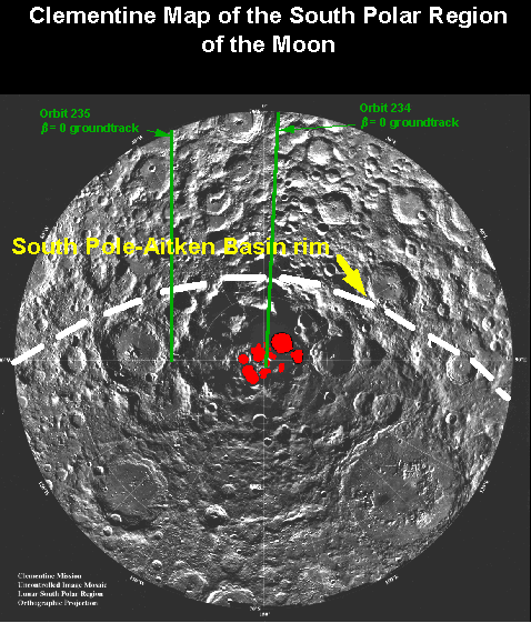
In the quest for detecting ice on the Moon, the radio transmitter onboard Clementine was used to bounce radio waves off the surface of the Moon to a station listening on the Earth. The energy of the reflected radio waves is a function of the compositional properties of the surface from which they are reflected. Rocky surfaces scatter radio waves randomly, while icy surfaces reflect radio waves coherently like a bicycle reflector. By distinguishing between weak radar returns and strong radar returns, it is possible to detect deposits of ice. Radar waves were bounced off of the Moon's north and south pole as well as areas around the poles. The radar ground tracks, shown in green, are illustrated on the south polar mosaic (the permanently dark regions are shown in red). The radar return from orbit 235, non-dark region, displays the characteristic radar return from a rocky silicate surface. Only orbit 234, which passed directly over the permanently dark regions at the south pole, has the radar reflectance properties of ice. Radar data collected from the north pole and other regions without permanent darkness do not have the ice signature.
- More About Ice at the South Pole of the Moon at PSRD
- More About Ice at the South Pole of the Moon at NSSDC
Clementine Multispectral Imaging of Mare Moscoviense
Introduction
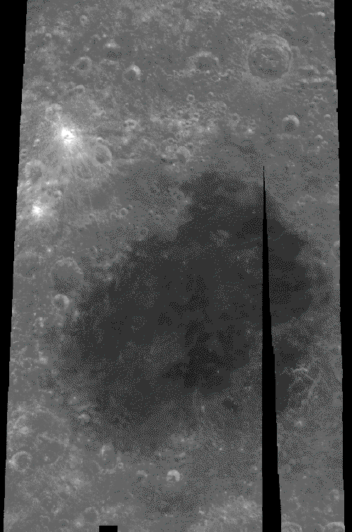
Results presented here are from Mare Moscoviense (26 degrees north and 147 degrees east, diameter 221 km). The processed data are from three out of the five bands acquired through the UltraViolet-VISible (UVVIS) camera.
Discussion
Grayscale images represent brightness measured in two dimensions over a surface. These images act as a first-order discriminant of surface composition based on overall albedo or brightness. For example, on the Moon, the feldsic lunar highlands are bright relative to the mafic basalts deposits (mare) which are dark in the image shown on the right. The boundaries between the mare and highlands units are easily delimited. In contrast, multispectral images record brightness in three dimensions, the X and Y directions are the same as before, and the third dimension is band depth. Reflectance is controlled by composition of the rock type and surface maturity. Different compositions have a characteristic pattern of reflection and absorption over the UVVIS spectrum. Therefore, by measuring surface brightness over a variety of discrete wavelengths, it is possible to identify the presence, absence, and access qualitative composition of surface units. For example, iron preferentially absorbs light around 1000 nm, whereas titanium preferentially absorbs light near 415 nm. If an absorption of light at either of these wavelengths is measured, 415 or 1000 nm, then it is inferred that the element with that characteristic absorption is present. Furthermore, the strength of the absorption is proportional to the amount of that particular element.

Three bands (415, 750, and 1000 nm) from the Clementine data have been used to create this false-color image. Images from the three bands are ratioed (750/415, 750/1000, and 415/750) and control the red, green, and blue components of the color composite image respectively. The image ratios reduce brightness variations due to albedo and topography, and the resulting image contains brightness variations due primarily to changes in lunar soil composition and maturity. The red channel represents areas that are low in titanium, or high in glass content, the green channel is sensitive to the amount of iron in the surface, and the blue channel reflects the surfaces with high titanium or bright slopes and albedos that are not compensated by using the image ratios. Lunar highlands appear red because they have accumulated glassy agglutinates produced during the bombardment of micrometeorites (maturation). Also red in the false-color image are pyroclastic deposits because of their naturally high-glass content. The yellow-green area in the mare is the combined effect of concentration of mafic minerals (green) and the glass in the soil produced by maturation (red). The blue unit in the mare is relatively higher in titanium compared to the mare unit to its immediate north.
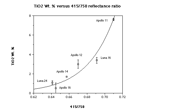
In order to extract quantitative abundance of titanium, groundtruth sites must be used to calibrate the sensor. Titanium composition of soils returned from Apollo missions 11, 12, 14, 16 and the Soviet's Luna 16 and 24 have been compared to the UV/VIS (415/750 nm) reflectance ratio from Clementine. Return samples from each of these missions have had their chemical abundance precisely measured in the lab. A plot of element weight percent versus 415/750 ratio reflectance value displays the correlation between the two components in this graph. This empirically derived titanium equation based on the Clementine data is only applicable for mature mare surfaces, so the input from the 415- and 750-nm filters had to be trimmed of the highlands areas before they were used in the calculations. Any reflectance value above an empirically determined limit is set to null in the 750-nm image and corresponding pixel in the 415-nm image. The output grayscale image from the equation was then binned into intervals that represent titanium weight percent from 0 through 2.5 and a look-up table designed to convey the data at 0.5 percent intervals [blue 0-0.5; cyan 0.6-1; green 1.1-1.5; yellow 1.6-2; and red 2.1-2.5]. The resulting pseudo-color image was then overlaid on top of the 750-nm grayscale image so the reader could observe the spatial relation of the two mare units to each other and the surrounding highlands.
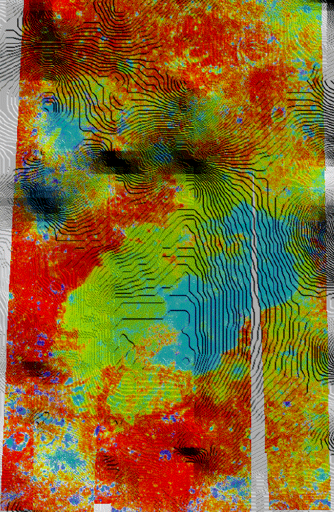
The colordrape image provides the perspective of where the eruptive centers for each of the mare units are located. The low-titanium units have erupted around most of the outer edge of the basin and have flowed downhill to the basin center. On the other hand, the high-titanium units emanated from only the eastern side of the basin. The vents for the high-titanium unit are also stratigraphically higher, which supports the model that as the basin is loaded with volcanics, compression increases in the center of the basin and extension increases at the edges.

Conclusions
Borrowing information from each of the datasets, I have compiled a geological map of Mare Moscoviense and the area surrounding it. Combining the information from all four datasets supplies a large amount of geological information that aids in accurately interpreting the complex processes that have produced the features one is studying. The grayscale mosaic provides contact relations between highlands and mare. Also apparent are structures and bright-rayed craters which are helpful for deciphering the color-composite image. The color-composite image reveals the surface maturity and composition. What appears as a single unit in the grayscale image is separated into two different chemical units based on multispectral reflectance. The colordrape yields where the lavas erupted from and which direction they flowed. Last but not least, the titanium image produces absolute numbers that we can use for direct comparison with other units and use to calculate abundance of titanium-oxide mineral phases present.
Clementine View of the Apollo 16 Landing Site
The area surrounding the Apollo 16 landing site in the image on the right has been imaged using the Clementine UVVIS data. The image below it is an Apollo metric photograph showing the landing site. The lunar module Orion touched down at 9 degrees S, 15.5 degrees E, approximately equidistant between the north and south ray craters. The Calyey Plains are an important region to study because samples collected during the Apollo 16 mission are used to calibrate orbital spectral data.


Combining the 415-, 750-, and 950-nm mosaics as blue, green and red channels respectively yields a true-color composite image of the landing site. The Moon's natural color is a faint red/brown. The blue tint seen in the Descartes mountains is the result of fresh ejecta from the crater Dollond E. Fresh crater ejecta is typically blue because it has not hand enough time to develop large amounts of iron-rich, red glass (agglutinates).

Ratioing the individual wavelength mosaics subdues brightness effects due to albedo and topography, and highlights color differences related to soil mineralogy and maturity. The red channel is controlled by the 750/415 ratio and is sensitive to soil maturity. The 750 to 950 ratio is sensitive to the presence of mafic minerals and is displayed as the green channel. Areas that are blue (415/750)in the image are the result of fresh soils or in mare, a concentration of the mineral illmenite (FeTiO3). Topographic features tend to be be washed out because Clementine images were taken at high sun angles. For this reason, the multispectral image is combined with the metric photograph. This allows correlations between the surface morphology and the spectral signatures.

The 750- and 950-nm images are combined to produce a quantitative map of FeO concentration accurate to approximately 1 weight percent. This map shows that the Cayley Plains and the Descartes Mountains appear to have similar compositions. The image shows that the amount of FeO in the Cayley plains to be approximately 4-5 weight percent. This calculation in consistent with return samples from this region.
Captions and images for this page were provided by Paul Spudis.
