Apollo 17 Landing Site Overview
Landing Site Selection
Because Apollo 17 was the last lunar landing of the program, all of the high-priority candidate landing sites were given consideration again. However, many were eliminated from consideration for either scientific or operational reasons. A landing near the central peaks of Copernicus crater had long been considered, but was now regarded as of lower priority, both because some Apollo 12 samples may have provided an age for this impact event and because three landings had already occurred in the vicinity of Mare Imbrium. A landing in the southern highlands near Tycho crater was rejected because of concerns about rough terrain and mission safety. A landing on the lunar farside in Tsiolkovsky crater was considered but rejected because of operational difficulties and the added expense of providing the communications satellites that would be necessary to maintain radio contact between the landing site and ground controllers. A highland site southwest of Mare Crisium was considered, but was rejected because this region of the Moon was easily accessible to spacecraft launched by the Soviet Union. In fact, the Luna 20 spacecraft landed in this region in February 1972, just a week after the Apollo 17 site selection was made, and returned 30 grams of samples to Earth for analysis.
This left three sites in the final consideration: Alphonsus crater; the central peaks of Gassendi crater, to the north of Mare Humorum; and the Taurus-Littrow valley on the eastern margin of Mare Serenitatis. The primary objectives were, in order of priority:
- Old highland material. The first priority was obtaining samples of old highlands material (older than the Imbrium impact) from as large a distance as possible from the Imbrium basin. All three of the final candidate sites were between 800 and 1000 kilometers from the Imbrium basin.
- Young volcanic material. The second objective was investigating the possible existence of young (less than 3 billion year old) volcanic activity. This was considered important both for understanding the thermal evolution of the Moon and also because interpretations of orbital photography suggested that young volcanism might have been explosive in nature and hence associated with a high abundance of volatile materials such as water.
- Orbital science. There were two competing objectives for obtaining orbital science coverage on the Apollo 17 mission. First, there was a desire to have orbital ground tracks that had minimal overlap with those of Apollo 15 and 16, so that the maximum amount of new information could be obtained. On the other hand, because Apollo 17 carried several new instruments, overlapping ground tracks with earlier missions would allow data from the new and old instruments to be compared over common areas.
- ALSEP Experiments. Finally, factors related to the Apollo Lunar Surface Experiments Package played less of a role on Apollo 17 than on some prior missions. This was because the seismometers, magnetometers, and laser ranging retroreflectors deployed on earlier missions formed networks across the Moon's surface, but no such network instruments were included on this mission. Although there was some desire to place the Heat Flow Experiment in an environment different from that on Apollo 15, this had no influence on the final site selection as both Apollo 15 and 17 landed very close to impact basin rims.
At the time of the Apollo 16 landing site selection, Alphonsus was regarded as the primary candidate for the Apollo 17 landing site. This site had the dual objectives of sampling highland material in the crater wall and possible young volcanic material at several dark-halo craters on the Alphonsus crater floor. However, there was concern that highlands materials in the Alphonsus crater wall were covered by later deposits and would be inaccessible to the crew. As sampling such material was the primary goal of the mission, the Alphonsus site was judged the least scientifically interesting of the three final candidates.
Gassendi was regarded as a scientifically interesting site which offered the possibility of sampling ancient highland rocks in the crater's central peak as well as providing ages for both the Humorum basin impact and the Gassendi crater impact. However, there were no known regions of possible young volcanism near the landing site. Moreover, the terrain just outside the planned landing site is quite rough, and if the crew landed in this region, it was not certain that they could achieve the primary objective of sampling Gassendi's central peaks. The orbital science potential was considered high for this mission, with little overlap with earlier missions. Also, Mare Orientale would have been overflown in sunlight for the first time in the Apollo program. However, these advantages were not sufficient to overcome the site's other difficulties.
Taurus-Littrow is a narrow valley in the Montes Taurus mountains, which form the rim of the Serenitatis impact basin. Samples obtained from the north and south walls of the valley were expected to provide the desired samples of ancient highland material as well as allow determination of the age of the Serenitatis impact event. In particular, a prominent landslide along the southern wall of the valley was expected to put highland material within reach of the crew. From orbit, the Apollo 15 crew had observed several craters in this region that are surrounded by deposits of very dark material. These so-called dark halo craters were interpreted as volcanic cinder cones. These were generally considered to be relatively young features, although some investigators pointed to features in the Apollo 15 photographs that indicated these deposits are actually very old. One of these craters, Shorty, was near the selected landing site and was another important objective of the mission. Finally, samples obtained from the floor of the valley would allow the age of the mare material to be determined. Despite the narrowness of the valley and the high (1.5 to 2 kilometers) mountains on either side, Apollo 15 photography showed that the Lunar Module could land safely in this region. Moreover, the primary objectives of the mission could be achieved even if the Lunar Rover failed. One drawback of this landing site is that it is at the boundary between mare basalts and a basin rim, an environment very similar to that sampled by Apollo 15. Nevertheless, the other advantages of this site led to its selection as the Apollo 17 landing site.
The landing site selected for Apollo 17 was in the Taurus-Littrow Valley on the eastern rim of Mare Serenitatis. The two primary objectives were obtaining samples of highland material that were older than the Imbrium impact and investigating the possibility of young, explosive volcanism in this region.
Orbital Views of the Landing Site
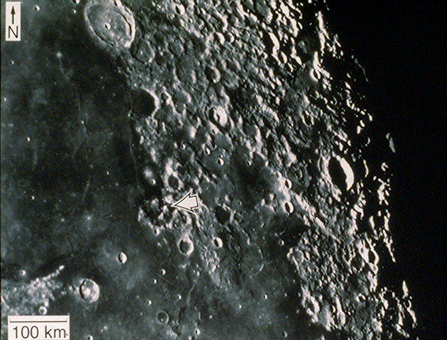
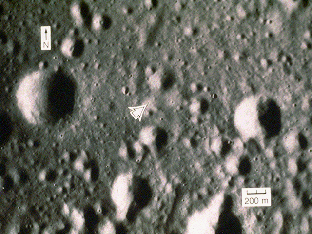
Apollo 17 site: Earth-based telescopic view
The arrow points to the landing site on the southeastern margin of Mare Serenitatis (circular basin at the left margin of the photograph). Mare Tranquillitatis is south of Mare Serenitatis. (Consolidated Lunar Atlas photograph C5, Lunar and Planetary Laboratory, University of Arizona.)
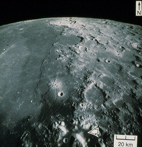
Apollo 17 site: Oblique view
The eastern margin of Mare Serenitatis displays a distinctive albedo contrast. Dark mare materials separate the rest of Mare Serenitatis from the rugged highlands to the east. The landing site is on the dark mare material present within the Taurus-Littrow valley (lower right), a tectonically produced break in the rim of the Serenitatis Basin. The Taurus-Littrow valley and its immediate surroundings have a lower albedo than most of Mare Serenitatis; the low albedo of the valley floor and the presence of dark "halos" around some of the craters led many scientists to believe, prior to the landing, that products associated with energetic volcanic eruptions should be present. (NASA photograph AS17-0939[M].)
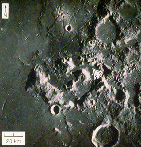
Apollo 17 site: Moderate resolution vertical view
The Taurus-Littrow valley is bounded on three sides by large mountains that compose a portion of the rim of the Serenitatis Basin; the three most prominent mountains around the landing site are South Massif, North Massif, and East Massif. Closely spaced domical hills, smaller in size than the massifs, compose the northeastern edge of the valley (Sculptured Hills, east of North Massif). Littrow Crater is the partly flooded crater north of the valley. (NASA photograph AS17-0447[M].)
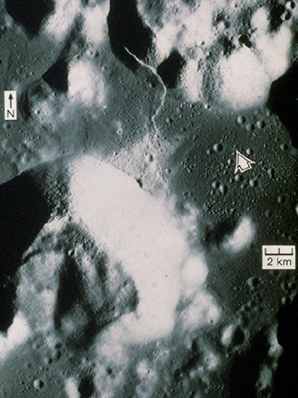
Apollo 17 site: High-resolution vertical view
A prominent topographic feature on the Taurus-Littrow valley floor is the Lincoln Scarp (which merges with the Lee Scarp near South Massif). The Lincoln Scarp crosses both the valley floor and the surrounding highland material in North Massif. The mantle of light material that extends across the valley floor from the base of South Massif was investigated during the second EVA by astronauts Eugene Cernan and Harrison Schmitt. North Massif and the Sculptured Hills (in the shadow northeast of the landing site) were visited by the crew during the third EVA. The crew discovered orange soil near the rim of Shorty Crater during the second EVA; later analysis of the soil revealed a large component of orange glass beads that were interpreted to be the product of volcanic eruptions. (NASA photograph AS17-2309[P])
Apollo 17 site: Enlargement of high-resolution view
The Lunar Module landed on the Taurus-Littrow valley floor among several 100-meter-sized craters. The first EVA included setting up the ALSEP station and an investigation of Steno Crater (the largest crater on the lower margin). The second EVA included traverses along the southern rim of Camelot Crater (large crater left of the landing site).(NASA photograph AS17-2309[P].)

Apollo 17 site: Approach view
This oblique picture of the Taurus-Littrow Valley, looking south-southwest, was taken from the Lunar Module one orbit prior to its landing. The valley is in the center of the picture, with South Massif above the valley and North Massif to the right. There is a cluster of small craters in the center of the valley. The LM landed just north of this cluster, to the right in this view. Mare Serenitatis is visible at the top of the picture, above the mountains. (NASA photograph AS17-147-22464.)
Stereoscopic Views of the Landing Site
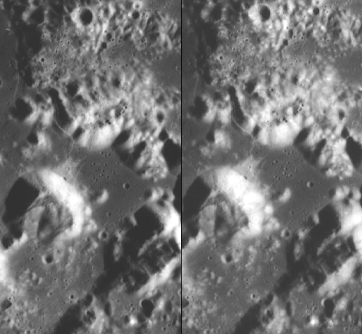

Stereo Viewing
Red/Green (Anaglyph) Images
To view anaglyph stereo pairs you need red-green (or red-blue) stereo glasses. These glasses have a red lens over the left eye and green (or blue) lens over the right eye.
Black and White Images
To view side-by-side stereo pairs, use pocket stereo viewers (obtainable from local educational suppliers, bookstores, etc.).
Side-by-side stereo pairs can also be viewed with the unaided eye by focusing on each image separately and allowing the eyes to cross. If you wear glasses, it may be necessary to remove them and view the pairs from 6 to 10 inches away. These techniques may require some practice (the Apollo 15, 16 and 17 stereo pairs are good for this purpose). Another means of assisting this process is to place an index card upright between the two images, forcing each eye to see the different images. Only approximately 10% of the general public cannot view images stereoscopically.
Surface Views of the Landing Site

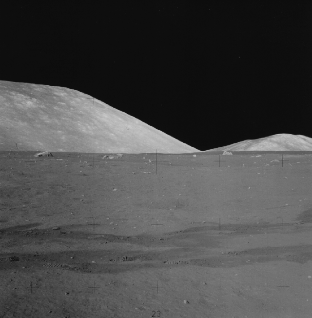
Looking North from the Apollo 17 Landing Site

Looking East from the Apollo 17 Landing Site

Looking South from the Apollo 17 Landing Site
Looking West from the Apollo 17 Landing Site