NASA’s Mars rover Curiosity has used autonomous navigation for the first time, a capability that lets the rover decide for itself how to drive safely on Mars.
This latest addition to Curiosity’s array of capabilities will help the rover cover the remaining ground en route to Mount Sharp, where geological layers hold information about environmental changes on ancient Mars. The capability uses software that engineers adapted to this larger and more complex vehicle from a similar capability used by NASA’s Mars Exploration Rover Opportunity, which is also currently active on Mars.
Using autonomous navigation, or autonav, Curiosity can analyze images it takes during a drive to calculate a safe driving path. This enables it to proceed safely even beyond the area that the human rover drivers on Earth can evaluate ahead of time.
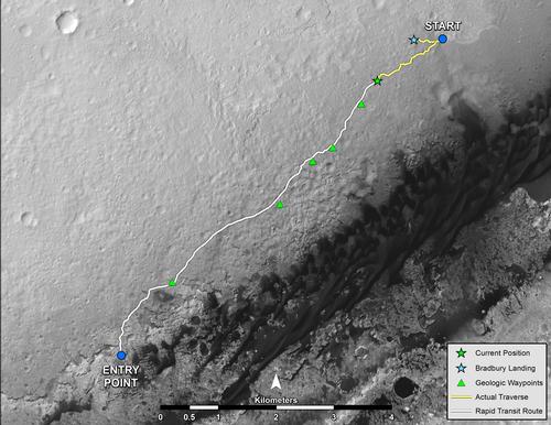
NASA’s Mars rover Curiosity left the “Glenelg” area on July 4, 2013, on a “rapid transit route” to the entry point for the mission’s next major destination, the lower layers of Mount Sharp. Image credit: NASA.
On Tuesday, Aug. 27, Curiosity successfully used autonomous navigation to drive onto ground that could not be confirmed safe before the start of the drive. This was a first for Curiosity. In a preparatory test last week, Curiosity plotted part of a drive for itself, but kept within an area that operators had identified in advance as safe.
“Curiosity takes several sets of stereo pairs of images, and the rover’s computer processes that information to map any geometric hazard or rough terrain,” said Mark Maimone, rover mobility engineer and rover driver at NASA’s Jet Propulsion Laboratory, Pasadena, Calif. “The rover considers all the paths it could take to get to the designated endpoint for the drive and chooses the best one.”
The drive on Tuesday, the mission’s 376th Martian day, or “sol,” took Curiosity across a depression where ground-surface details had not been visible from the location where the previous drive ended. The drive included about 33 feet (10 meters) of autonomous navigation across hidden ground as part of a day’s total drive of about 141 feet (43 meters).
“We could see the area before the dip, and we told the rover where to drive on that part. We could see the ground on the other side, where we designated a point for the rover to end the drive, but Curiosity figured out for herself how to drive the uncharted part in between,” said JPL’s John Wright, a rover driver.
Curiosity is nearly two months into a multi-month trek from the “Glenelg” area, where it worked for the first half of 2013, to an entry point for the mission’s major destination: the lower layers of a 3-mile-tall (5-kilometer-tall) mound called Mount Sharp.
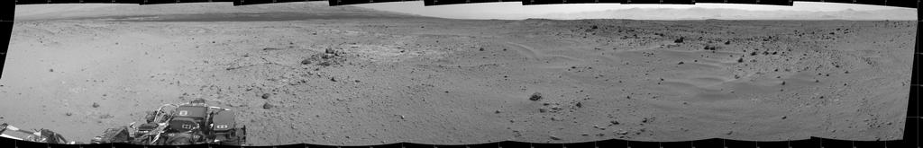
This mosaic of images from the Navigation Camera (Navcam) on NASA’s Mars rover Curiosity shows the scene from the rover’s position on the 376th Martian day, or sol, of the mission (Aug. 27, 2013). Image credit: NASA.