NASA’s Mars rover Curiosity has resumed a trek of many months toward its mountain-slope destination, Mount Sharp. The rover used instruments on its arm last week to inspect rocks at its first waypoint along the route inside Gale Crater.
The location, originally chosen on the basis of images taken from NASA’s Mars Reconnaissance Orbiter, paid off with investigation of targets that bear evidence of ancient wet environments.
This mosaic of four images taken by the Mars Hand Lens Imager (MAHLI) camera on NASA’s Mars rover Curiosity shows detailed texture in a ridge that stands higher than surrounding rock. Image Credit: NASA/JPL-Caltech/MSSS.
“We examined pebbly sandstone deposited by water flowing over the surface, and veins or fractures in the rock,” said Dawn Sumner of University of California, Davis, a Curiosity science team member with a leadership role in planning the stop. “We know the veins are younger than the sandstone because they cut through it, but they appear to be filled with grains like the sandstone.”
This Waypoint 1 site at an outcrop called “Darwin” is the first of up to five waypoint stops planned along the route of about 5.3 miles (8.6 kilometers) between the “Glenelg” area, where Curiosity worked for the first half of 2013, and an entry point to the lower slope of Mount Sharp, the mission’s main destination. It is about one-fifth of the way along the route. The rover departed Waypoint 1 on Sept. 22 with a westward drive of about 75 feet (22.8 meters).

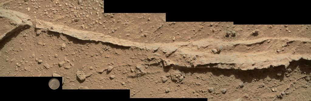
This mosaic of nine images, taken by the Mars Hand Lens Imager (MAHLI) camera on NASA’s Mars rover Curiosity, shows detailed texture in a conglomerate rock bearing small pebbles and sand-size particles. Image Credit: NASA/JPL-Caltech/MSSS.
Curiosity’s science team planned the waypoints to collect information about the geology between Glenelg and Mount Sharp. Researchers want to understand relationships between what the mission already discovered at Glenelg and what it may find in the multiple layers of Mount Sharp. Analysis of drilled samples from veined “Yellowknife Bay” rocks in the Glenelg area provided evidence for a past lakebed environment with conditions favorable for microbial life. That means the mission has fulfilled its principal science goal.
“We want to understand the history of water in Gale Crater,” Sumner said. “Did the water flow that deposited the pebbly sandstone at Waypoint 1 occur at about the same time as the water flow at Yellowknife Bay? If the same fluid flow produced the veins here and the veins at Yellowknife Bay, you would expect the veins to have the same composition. We see that the veins are different, so we know the history is complicated. We use these observations to piece together the long-term history.”
Researchers set the top priority for the Waypoint 1 stop to be examination of a conglomerate rock outcrop, such as the pebbly sandstone. The veins were a bonus.