
Discovering the Impact Site
These findings led to an extensive search for a large impact crater that is 65 million years old. Seven North American researchers finally located the impact site on the Yucatán Peninsula.
The key to that success was a discovery in Haiti of an unusually thick sequence of impact ejecta. Alan Hildebrand and David Kring measured a deposit of debris that was ~0.5 meters thick. Subsequent laboratory analyses showed the deposit was dominated by impact melt spherules and that it contained an unusually large amount of shocked quartz, both of which unambiguously indicated the deposit was ejected from an impact crater. Because the deposit was so thick — and far thicker than any other previously measured K-T boundary section — they, along with Bill Boynton, deduced the K-T boundary impact had occurred in the Gulf of Mexico or Caribbean region.
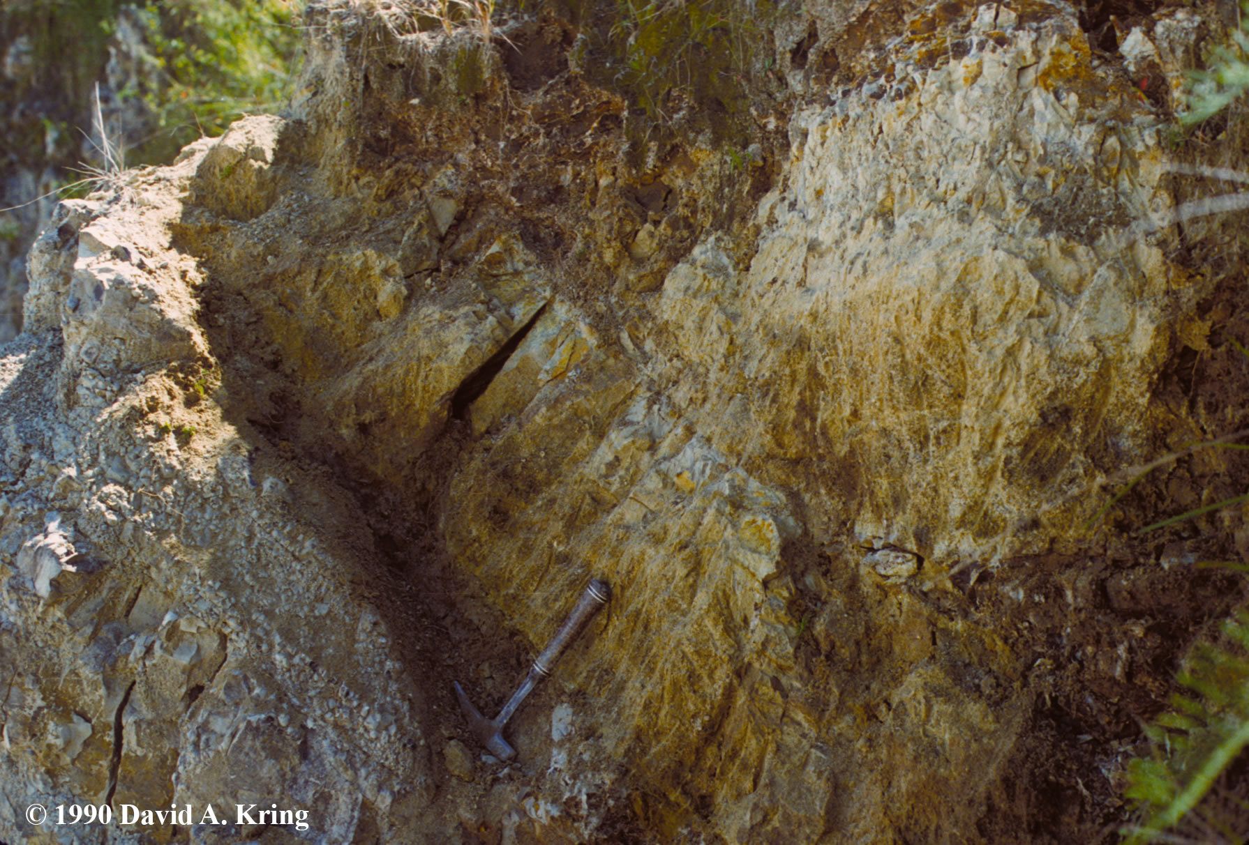
Thick Impact Ejecta Deposit at the K-T Boundary in Haiti
The field work that catalyzed the discovery of the Chicxulub crater occurred in Haiti, on the southern peninsula of the island of Hispaniola, where previously, Florentin Maurrasse had located the K-T boundary. There, thick deposits of impact melt spherules, capped with a layer of iridium-rich, and shocked quartz-bearing sediment, were measured by Alan Hildebrand and David Kring in February 1990. The primary thickness of the impact ejecta deposit is ~46 centimeters, as shown here, near the town of Beloc, Haiti. In other areas, the impact ejected materials appear to have been reworked by seafloor bottom currents, producing deposits up to 125 centimeters thick. The deposit of impact debris in Haiti was far thicker than it was at any other location known at that time (e.g., ~1 centimeter-thick deposits were known in New Mexico and Colorado), which indicated the K-T boundary impact must have occurred somewhere in the Gulf of Mexico or proto-Caribbean region.
Photographic Credit: David A. Kring
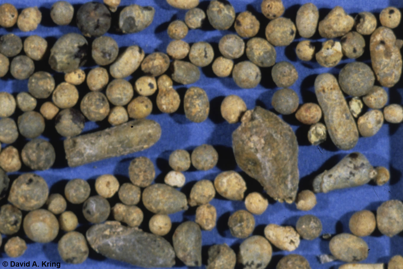
Impact Melt Spherules at the Cretaceous-Tertiary (K-T) Boundary
One of the important products of an impact cratering event is impact melt. A fraction of that melt is ejected from the crater. When the melt is ejected from a crater, it separates into molten droplets that quench to glass in the atmosphere before landing. Those glassy beads can form a layer of ejecta, both on land or on a seafloor. An unusually thick, half-meter deposit of impact melt spherules was discovered at the K-T boundary on Haiti. That was important information, because it indicated the source crater was in the region. The composition of the impact melt spherules was also important, because it indicated the impact occurred in an area with continental crust, rather than oceanic crust. Up to that point, many investigators favored an impact into oceanic crust. The spherules shown here were collected from that deposit in Haiti. They are about 1 millimeter in size. The largest particle in the image has a length of about 4 millimeters, but spherules up to 10 millimeters were observed. The spherules shown here were described by David A. Kring and William V. Boynton (1991, Altered spherules of impact melt and associated relic glass from the K/T boundary sediments in Haiti, Geochimica et Cosmochimica Acta 55, 1737-1742). The composition of the relic glass was subsequently linked directly to the Chicxulub crater, demonstrating that the Chicxulub impact occurred precisely at the K-T boundary (Kring and Boynton, Nature 358, 141-144, 1992).
Photographic Credit: David A. Kring

Shocked and Unshocked Quartz at the Cretaceous-Tertiary (K-T) Boundary
Quartz is a common mineral in the Earth’s continental crust. When an impacting asteroid and/or comet hits that crust, it produces enormously high shock pressures. Those shock pressures can generate shock lamellae or planar deformation features through quartz crystals. Along those planes, the crystal structure has been completely destroyed, producing a zone of glass. That type of damage is not produced by any other geologic process, so the features are diagnostic evidence of an impact event. On the left is an unshocked quartz grain. On the right is a shocked quartz crystal that was ejected from the Chicxulub impact crater and deposited in K-T boundary sediments in Haiti. The quartz crystal is 0.45 millimeters long. This crystal and thousands of others were described by D. A. Kring, A. R. Hildebrand, and W.V. Boynton, 1994, Provenance of mineral phases in the Cretaceous-Tertiary boundary sediments exposed on the southern peninsula of Haiti, Earth and Planetary Science Letters 128, 629-641.
Photographic Credit: David A. Kring
A search of the region located a buried semi-circular structure on the Yucatán Peninsula. It had been identified decades earlier using geophysical techniques and exploration boreholes drilled in search of petroleum, but was interpreted to be a buried volcanic center with intrusive and extrusive andesite with pyroclastic tuff. Two samples from depths of 1.2 and 1.3 kilometers in one of the boreholes into the structure were re-examined and found to contain diagnostic evidence of an impact origin. The melt rocks and breccias within the structure are not the product of magmatic intrusions and extrusions as previously interpreted, but rather the consequences of an impacting near-Earth asteroid (or possibly comet) with the kinetic energy equivalent to ~100 million megatons of TNT. The breccias covering the upper Cretaceous elsewhere on the Yucatán Peninsula were neither volcanic or debris eroded from tectonic uplifts as previously presumed, but products of more than ten thousand cubic kilometers of debris ejected from a crater. That discovery was reported by Kring, Hildebrand, and Boynton at the 1991 Lunar and Planetary Science Conference. At that same meeting, Glen Penfield and Antonia Camargo Z. described the geophysical elements of the subsurface structure. The results in both those papers were integrated with an additional geophysical analysis by Mark Pilkington and an isotopic analysis by Stein Jacobsen in a paper published later that year by Hildebrand et al. (Geology 19, 867-871, 1991). Additional geochemical details linking the Chicxulub impact melt rock to the K-T boundary deposit in Haiti followed (Kring and Boynton, Nature 358, 141-144, 1992), showing that the Chicxulub crater was produced precisely at the K-T boundary.
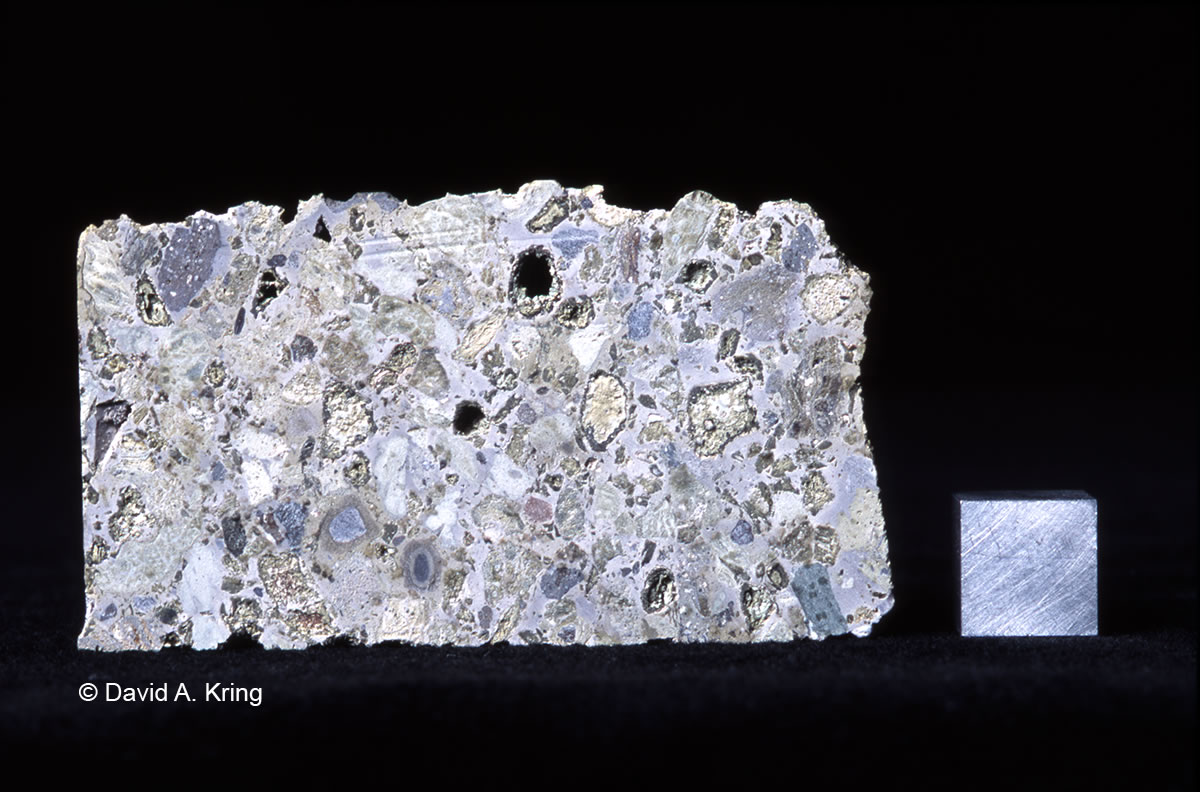
Chicxulub Impact Breccia
The discovery of shocked quartz, shocked feldspar, and impact melts in the Yucatán-6 exploration borehole from the interior of the Chicxulub structure, proved it was an impact crater and that it was produced at the Cretaceous-Tertiary (K-T) boundary. This is a photograph of one of the two samples behind that discovery. The sample is a polymict breccia recovered from a depth of ~1.2 kilometers in the Yucatán-6 borehole. Beneath the polymict breccia is a melt rock sample that was recovered from a depth of ~1.3 kilometers. The discovery was initially reported by David A. Kring, Alan R. Hildebrand, and William V. Boynton at the 1991 Lunar and Planetary Science Conference. Additional details about this sample were subsequently published by Hildebrand et al. (Geology 19, 867-871, 1991) and Kring and Boynton (Nature 358, 141-144, 1992)
Photographic Credit: David A. Kring

Chicxulub Shocked Quartz Crystal
The discovery of shocked quartz, shocked feldspar, and impact melts in the Yucatán-6 exploration borehole from the interior of the Chicxulub structure, proved it was an impact crater and that it was produced at the Cretaceous-Tertiary (K-T) boundary. This is one of the microscopic images of shocked quartz crystals that were shown at the 1991 Lunar and Planetary Science Conference where the Yucatán-6 samples were first described. The shocked quartz was produced when the K-T boundary impactor hit the continental crust of the Yucatán Peninsula, producing a shock wave that radiated into the crust. Those shock pressures can generate shock lamellae or planar deformation features through quartz crystals. Along those planes, the crystal structure has been completely destroyed, producing zones of glass. In this crystal, there are two sets of planar deformation features oriented in different directions. That type of damage is not produced by any other geologic process, so the features are diagnostic evidence of an impact event. This sample was initially described by David A. Kring, Alan R. Hildebrand, and William V. Boynton at the 1991 Lunar and Planetary Science Conference. Additional details about this sample were subsequently published by Hildebrand et al. (Geology 19, 867-871, 1991) and Kring and Boynton (Nature 358, 141-144, 1992)
Photographic Credit: David A. Kring

Chicxulub Impact Melt Rock
The discovery of shocked quartz, shocked feldspar, and impact melts in the Yucatán-6 exploration borehole from the interior of the Chicxulub structure, proved it was an impact crater and that it was produced at the Cretaceous-Tertiary (K-T) boundary. This is a microscopic image of the impact melt rock, which is one of the two samples behind that discovery. The sample was produced when the impactor melted the Earth’s crust. A large fraction of that melt pooled within the crater, cooled, and solidified. Unmelted quartz and feldspar mineral relics from the target rocks were caught in the melt; a relic quartz grain is visible in the center of the picture. The melt began to crystallize as it cooled. The first crystals nucleated on the quartz grain, producing a corona of crystals. The remaining melt also crystallized, but the crystals are much smaller in the surrounding area. Much later, impact-generated fluids cut through the rock in veins. Secondary quartz crystallized in those veins, which are visible in the upper and lower right of the picture. Some of the relic quartz and feldspar have planar deformation features, or shock lamellae, which indicates the melt was produced by an impact. In addition, the melt has a composition that is not produced by magmatic processes on Earth, but is the type of composition produced by an impacting asteroid that melts the crust of the Earth. This sample was initially described by David A. Kring, Alan R. Hildebrand, and William V. Boynton at the 1991 Lunar and Planetary Science Conference. Additional details about this sample were subsequently published by Hildebrand et al. (Geology 19, 867-871, 1991) and Kring and Boynton (Nature 358, 141-144, 1992)
Photographic Credit: David A. Kring
The researchers called the crater Chicxulub, a Maya word that roughly translates as “tail of the devil.” The crater, now buried beneath a kilometer-thick sequence of sediments, has been imaged using geophysical techniques that allow us to visualize underground structures. The crater appears to have a diameter of ~180 kilometers, which makes it one of the largest confirmed impact structures on Earth. Only Sudbury in Canada and the Vredefort structure in South Africa could potentially be larger.
The discovery of the Haitian K-T boundary deposit and Chicxulub crater catalyzed the scientific community. A large number of papers quickly followed. Collectively the links between the Chicxulub crater and constituents of the K-T boundary include a crater-filling impact melt with a similar chemical composition and radiometric age as impact melt spherules deposited at the K-T boundary in Haiti; an ejecta thickness at the boundary that decreases radially away from the Chicxulub crater; shocked quartz grain sizes in boundary sediments that decrease with radial distance from the Chicxulub crater; shocked quartz, feldspar, and lithic fragments in boundary sediments similar to Chicxulub basement rocks; unshocked zircon in boundary sediments that are consistent with the age of Chicxulub basement rocks; and shocked zircon in boundary sediments with the same age as the Chicxulub crater.

Click on the image to initiate a short slide show.
The crater currently underlies the northern coastline of the Yucatán Peninsula, as can be seen in gravity maps of the area. At the time of impact, the Gulf of Mexico covered the northern part of the peninsula, so the impact occurred into a shallow sea. Sedimentation on the floor of the gulf filled in the crater and eventually buried it beneath several hundred to ~1 kilometer of sediment. The Chicxulub crater is not visible at the Earth’s surface like the famous Meteor Crater of Arizona.
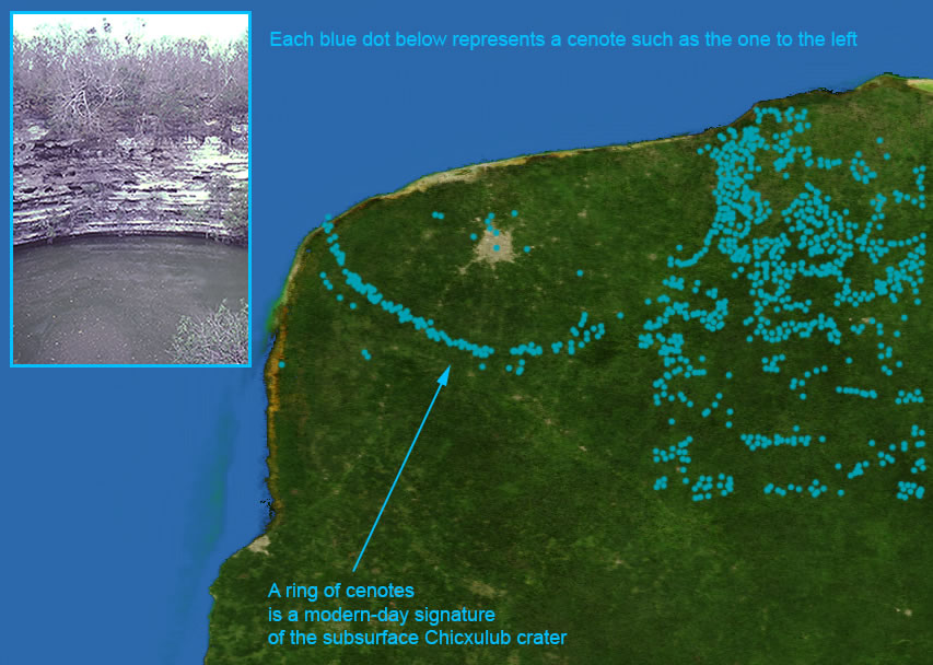
There are, however, two surface expressions of the crater. Radar measurements captured from one of NASA’s space shuttles detected a subtle depression in the sediments that bury the crater. In addition, the subsurface rim of the crater has affected groundwater flow. In the recent geologic past, and continuing today, groundwater flowing north in the peninsula encounters that rim and is deflected around the crater. That enhanced groundwater flow has dissolved the limestone, producing a series of sinkholes that are filled with water. Locally those sinkholes are called cenotes. Thus, a ring of cenotes outlines the crater.

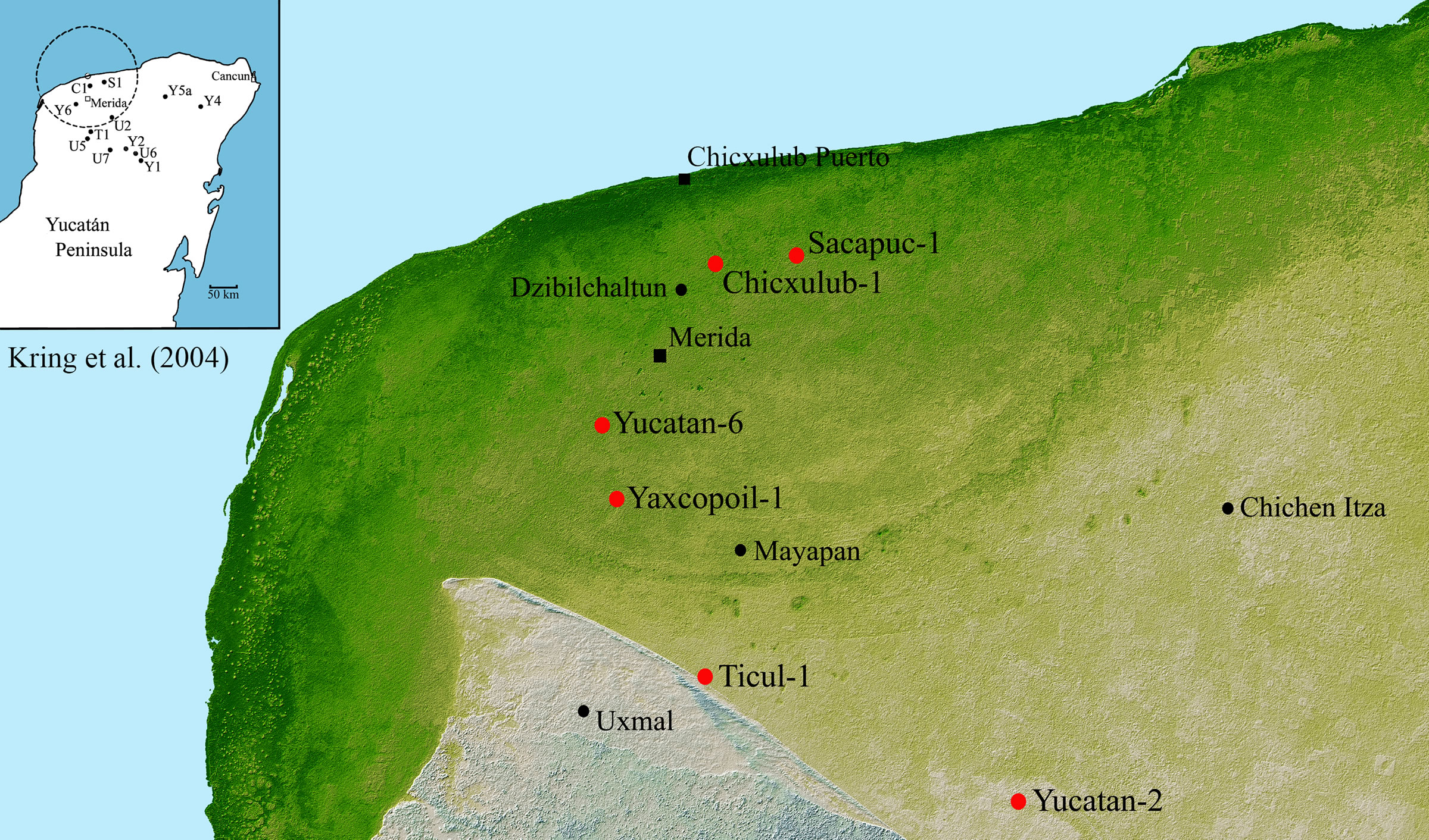
Chicxulub Gravity Map and Boreholes
The subsurface structure of the Chicxulub crater can be seen in a gravity map of the northwestern margin of the Yucatán Peninsula. A black circle outlines the ~180 kilometer diameter crater. The original petroleum exploration borehole locations (C1, S1, and Y6) are shown where intermittent core was recovered. That core was sufficient, however, to prove the crater had an impact origin. A scientific borehole was drilled near the Haciende Yaxcopoil (Yax-1) in 2001-2002 and produced continuous rock core for study. A borehole is being drilled at sea (Chicx-03A) in 2016.
Illustration Credit: David A. Kring
Radar Tomography Map of Chicxulub
The shaded relief map was produced by the Shuttle Radar Tomography Mission on Space Shuttle Endeavor in 2000. A three to five meter deep semicircular trough (darker green arcing line) lies at a slightly smaller radius than a belt of cenotes which occur approximately above the crater rim. The Chicxulub-1, Sacapuc-1, Yucatán-6, and Yaxcopoil-1 boreholes are within the rim of the crater. The original diagnostic evidence of shock-metamorphism and an impact origin for the structure was recovered from Yucatán-6 (Y6). All of the PEMEX exploration boreholes (C1, S1, T1, Y1, Y2, Y4, Y5a, Y6), which were often >1 km deep, were incompletely sampled (see inset). Newer UNAM exploration boreholes (U2, U5, U6, U7) recovered continuous core, but are part of a shallow (ranging from ~60 m to ~700 m) drilling program. Only U5, U6, and U7 encountered impact lithologies. The dotted line in the inset outlines the ~170 to 180 km central region of the crater, which many investigators believe is the rim of the crater. The shaded relief image was produced by NASA, the National Imagery and Mapping Agency (NIMA) of the U.S. Department of Defense and the German and Italian space agencies. Reproduced from a paper by Kring et al. (Meteoritics & Planetary Science 39, 879–897, 2004).
Illustration Credit: David A. Kring
Chicxulub Zone of Cenotes
In the mid-20th Century, a ring of cenotes appeared on topographic maps of the Yucatán Peninsula. The cause of the ring was unknown, until the Chicxulub Crater was discovered. Groundwater flowing north through the limestone of the Yucatán Peninsula encounters the buried rim of the crater, which is like a buried ring of mountains. The water flow is deflected around the crater and flows (visibly) into the Gulf of Mexico where the northern coastline of the peninsula overlies the crater rim. The concentrated fluid flow has dissolved the overlying limestone, producing cenotes, which are water-filled sinkholes. The chain of cenotes, like a blue-pearl necklace, surrounds the crater. A version of this diagram was initially crafted by Jake Bailey and David Kring for the NASA/Univ. Arizona Space Imagery Center. It was recently modified by the LPI for its collection of classroom illustrations.
Illustration Credit: LPI
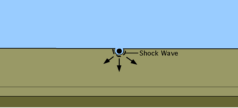
The Chicxulub crater is a peak-ring impact basin. Small craters, like Arizona’s Meteor Crater, are simple bowl-like structures. When craters exceed 2 to 4 kilometers in diameter on Earth, a central peak rises from the crater floor and the walls of the crater collapse to form a series of benches called the modification zone. When craters are very large, like Chicxulub, that central peak collapses to form a peak ring. We have two animations of that process below. The first is a schematic representation of that process (top). The second is a complex computer hydrocode simulation of the process (bottom).
Peak-Ring Crater Animation
Animation Credit: Jake Bailey
Click on the image to view the animation.

Chicxulub Hydrocode Simulation
In this simulation, an asteroid hits a layered target composed of carbonate platform sediments overlying granitic continental crust and the mantle. On impact, a transient cavity opens up, reaching a maximum depth of 32 kilometers 20 seconds after impact. The crater floor then begins to rise. The maximum cavity volume is generated after 55 seconds while the crater floor continues to rise. The central uplift surpasses the pre-impact target surface 2 minutes after impact and reaches a maximum height of ~15 kilometers at ~3 minutes. As the central uplift collapses, granitic material is spread out over the surface burying the carbonate platform sediments. After ~8 minutes the crater formation process is complete. The final crater has a rim-to-rim diameter of ~160 kilometers; the peak ring, formed by the collapsing central uplift, has a diameter of ~90 kilometers. At depth, the crater collapse process has uplifted the crust/mantle boundary by ~2 kilometers beneath the crater center and created a slight thickening (~1 kilometer) of crustal material 35 kilometers out from the center. This hydrocode simulation was produced for LPI’s Video Simulations of Impact Cratering Processes, which was designed by Ross Potter and David Kring to teach how the parameters of impacts on the Earth, Moon, and other planetary bodies affect the growth of craters.
Video Credit: Ross W. K. Potter
Any other use of the information and images requires permission of David A. Kring and the LPI.
This web site is an updated version of information originally created for the University of Arizona Space Imagery Center's Impact Cratering Series.

