

Scars from Europa’s Polar Wandering Betray Ocean Beneath
By Paul Schenk
Europa is a complex and dynamic moon, but now, global mapping of unusual large circular features on the ice-covered ocean world of Europa has revealed that Jupiter’s curious icy moon is even more unstable than previously thought.
Europa’s Crop Circles
The features are some of the most enigmatic on the ice-shrouded moon (Fig. 1). They are long troughs, or depressions, in the surface a few tens of kilometers wide and several hundred kilometers long (1 kilometer equals just over half a mile). The troughs are in fact gentle downward swells: You would not notice them if you were walking across Europa. They are not straight but form large arcuate traces on the surface. Also nearby are several sets of smaller but equally prominent depressions.
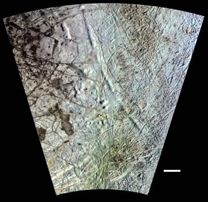 |
Fig. 1. Western portion of one of two known concentric circles on Europa believed to be due to true polar wander of the icy shell. The long arcuate trough or depression sweeping diagonally across the top of the scene is roughly 40 kilometers wide and 500 kilometers long. A smaller deeper depression lies just to the west near the top of the frame. This Voyager-Galileo mosaic has an effective resolution of 1.5 kilometers. Scale bar is 100 kilometers long. |
Images from three NASA spacecraft were required to complete the global map of these features, but even so, one major segment was never mapped (due to the lack of any early morning or late afternoon images that produce the shadows necessary to see the features). One of these arcuate troughs was first seen by Voyager (Fig. 2) during its thrilling pass through the Jupiter system in 1979. But Voyager only saw a small section of the surface. It remained for the Galileo spacecraft to map the rest of this unique world, but as Galileo began its journey to Jupiter in the early 1990s, its parabolic antenna jammed, and the spacecraft would never finish its global mapping mission (an important task left to a future mission). Galileo returned hundreds of astounding high-resolution images but only a handful of global images. These images have shown more of these strange arcuate features, but only recently has mapping of the full dataset revealed their extent and the peculiar global pattern they form.
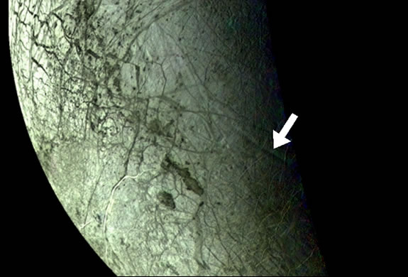
Fig. 2. The Voyager discovery mosaic showing part of one of two sets of concentric troughs on Europa. Until the Galileo mission, the origin of this feature and its relationship to Europa’s other ubiquitous tectonic features remained a complete mystery. |
 |
When finally mapped out globally (see Fig. 3), these arcuate troughs and depressions form two startlingly similar circular patterns 2500 kilometers (1550 miles) wide, one each on exactly opposite sides of Europa. Although on opposite hemispheres, the two circles are both oddly displaced from the equator and from the Europa-Jupiter axis. The startling circularity and symmetry of these patterns prompted Schenk to euphemistically refer to them as Europa’s “crop circles.”
 |
Fig. 3. Part of a global map showing the location of the concentric circles formed by arcuate troughs or depressions on the leading hemisphere of Europa. The large dot is the geometric center of the circular features, which are the thick black lines. This is the location of the best imaging coverage. A full global map is shown in the Nature article by the authors. |
A Planetary Detective Story
Once they had discovered the bizarre concentric circular pattern, a team of scientists began the search for the mechanism that produced them. The team was led by Dr. Paul Schenk of the Lunar and Planetary Institute of Houston, Texas, joined by Dr. Isamu Matsuyama of Carnegie Institute of Washington and Dr. Francis Nimmo of theUniversity of California, Santa Cruz. The full results of their mapping and analyses appeared in the May 15 issue of Nature magazine. Full details of the circles and their proposed mechanism can be found there.
It was not an easy search. One reason was that these troughs are far apart on the surface, and the pattern was no obvious until complete mapping was done of the surface. Another reason is that these features are not centered on or symmetric to the current equator. This was the first suggestion that some type of rotation was needed, but what? Several mechanisms (thought to explain many of Europa’s other tectonic features) were tested. Nonsynchronous rotation of the icy shell and daily (or diurnal) tidal distortions as high as 30 meters (100 feet) have been proposed as explanations for many of the ubiquitous faults and ridges that smother the surface of Europa, but none of these matched the positions of the strange circular troughs.
A third global stress force has also been proposed, called true polar wander (TPW). In this mechanism, proposed by Greg Ojakangas and David Stevenson back in 1990, the whole outer ice shell of Europa (or any other icy body for that matter) can change orientation such that the polar regions migrate to the equator, even as the rocky inner bulk of Europa continues to spin about its axis in the normal 3.5-day fashion. This process probably occurs only within the outer icy shell, believed to be 10 to 20 kilometers (6 to 12 miles) thick. Polar wander is driven by cold polar temperatures, which lead to a thickening of the icy shell there, creating a mass imbalance.
Several scenarios were tested before the team finally hit upon the rotation that best matched the observed features: 80° of polar wander (essentially a complete flop-over of the poles to the equator), coupled with a minor bit of nonsynchronous rotation. Mapping of other features had hinted at the possibility of TPW, but only 20% of the surface can be so mapped and a true global map does not exist. Hence it was not possible to confirm the occurrence of TPW until these global-scale features were mapped.
What was surprising was the degree to which other geologic features also fit this pattern (Fig. 4). “I have long suspected that Europa’s fracture patterns were much more symmetric than they appear on our maps,” said Schenk. This is due to the fact that geologic mappers usually view the spherical surface of a planet on distorted map projections, and normally in maps centered on the current equator. When we found the polar wander scenario that best fit the circles, other large tectonic features suddenly fit into a globally symmetric pattern that lined up with this stress field.”
 |
|
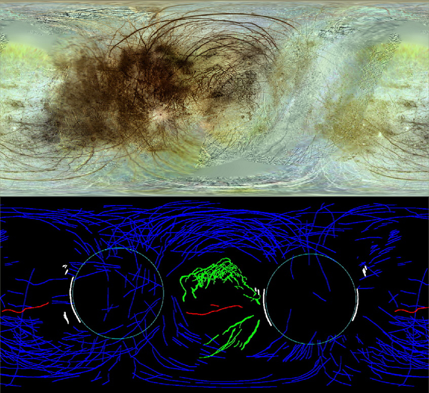
| Fig. 4. A new global mosaic (top) and corresponding map (bottom) of Europa shows the symmetry of its global tectonic pattern. This simple cylindrical map projection (the north pole is at top, the south at bottom) shows Europa, not as we would see it today, but rather after rotation of the surface so that the stress equator of the TPW solution is now coincident with the map projection equator. The long dark lineaments (blues lines) appear to form a “web” centered around the zone of wedge-shaped band strike-slip faulting (green lines) and the bright bands Agenor and Corick Linea (red lines). The long dark lineaments also radiate from the centers of the concentric circles (white arcs). Note that some of the large-scale lineaments to the south are relatively bright to the very oblique viewing in those images | |
Bands and ridges and other features thought to be due to other geophysical forces or to have no apparent pattern were now shown to be symmetric about these polar wander stresses. “They had simply been formed or shifted into a pattern that was not symmetric about the current equator, so we only glimpsed part of it before. Making this new map simply allows us to see the full symmetry of these patterns for the first time,” Schenk continued.
Is Polar Wander Common?
Confirmation of true polar wander on Europa provides yet another example of a geophysical process that is just beginning to be properly appreciated. Mars has probably tilted over at least once, due to the formation of the massive Tharis volcanos. Paleomagnetic measurements in ancient rock samples indicate that Earth has also experienced rapid episodes of polar wander in the past. Enceladus appears to have done so, explaining the presence of plumes at the south pole, and possibly Miranda as well. Polar wander is beginning to look like a common process across the solar system, suggesting that planets in general are perhaps a bit more unbalanced than we had thought.
Polar Wander and Europa’s Ice Shell
True polar wander has one important prerequisite: It is vastly easier to rotate the ice shell, which weighs at least a billion billion metric tons, if it is floating on liquid water. Galileo has provided other evidence for a liquid ocean not far beneath Europa’s icy surface, via magnetic field measurements and geologic observations. “The large reorientation on Europa required to explain the circular depressions implies that its outer ice shell is decoupled from the core by a liquid layer,” said Matsuyama. “Therefore, our study provides an independent test for the presence of an interior liquid layer.”
The discovery of TPW does not yet provide a measurement of the ice shell thickness, an issue of great interest to scientists and mission engineers alike, but the depths of these features do. The deepest of these troughs and depressions are over a kilometer (perhaps 1.5 kilometers) deep, plus they are unmarred by later geologic activity (Fig. 5). Such relief on a floating ice shell is not compatible with thin ice shells or shelves such as seen in the Antarctic. Only a relatively strong thick ice shell could support such relief, and preliminary estimates are that the shell is at least 6 to 10 kilometers (roughly) based on these features. This is consistent with earlier estimates, based on impact crater studies and thermal models that the ice shell is 10 to 20 kilometers thick. These are not very precise estimates, however, and determining the true ice thickness and depth to the ocean remains the job of a future Europa orbiter.
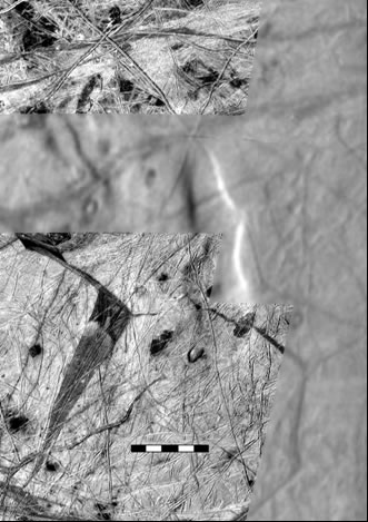 |
Fig. 5. Our best image of any of the concentric circles. This Galileo mosaic consists of a partial mosaic at 230-meter resolution with global images at 1.5-kilometer resolution as background. This depression measures 40 by 150 kilometers and is at least 1 kilometer deep (the deepest known feature on Europa). A wedge-shaped band is visible at lower left. The scale bar is 50 kilometers long. |
What’s Next?
The concentric circles and global-scale dark bands may be the “smoking gun” of true polar wander on Europa, but other smaller-scale features such as strike-slip faults and disrupted terrains called “chaos” may also have formed during this tectonic episode (or have been rotated by it). Mapping by others had suggested the possibility of polar wander, but the maps that were available only covered 20% or so of the surface at better than 1-kilometer resolution, and it was difficult to make firm conclusions. New mapping is required to test this new model, work that will begin this summer by the team at the LPI and institutions in Maryland, Washington, DC, and California. Determining when this event took place is also important but will require detailed mapping to work out. Features and patterns that had been thought to be explained by other forces may in fact be better explained by this episode of true polar wander, an event that may have fundamentally reshaped Europa’s geology and surface. A new mission to map the global geology of Europa and unravel these tectonic patterns is of key importance to understanding this ocean world and its evolution. Concludes Schenk, “This changes how we will look at Europa’s geologic history.”
Image Credits: All figures by Dr. Paul Schenk, Lunar and Planetary Institute
This article may be cited as:
Schenk, P. (2008) Scars from Europa’s polar wandering betray ocean beneath. Available online at http://www.lpi.usra.edu/science/schenk/europaCropCircles/.
Last
updated
May 14, 2008
